Graupel and supercooled rain predict lightning better than ZDR columns at 6 minutes
In 15 isolated South China thunderstorms, graupel and supercooled rain content gave the best 6-minute lightning forecasts, while ZDR column volume looked better at 12 minutes.
Why it matters
Radar signs of updraughts and cloud particles are used to warn of lightning. This study suggests which signs work best at which warning time. It also gives a picture of how ZDR and KDP columns relate to different stages of a storm pulse, which may explain why they behave differently.
What they did
The authors studied 15 isolated thunderstorm cells using an S-band dual-polarization radar and a 3D lightning detection array. They built a “3D mapping columns” method that finds ZDR and KDP columns on a Cartesian grid, without a reflectivity cutoff, so it works in the early cloud stage. They retrieved rain, ice and graupel content and identified hydrometeor types and microphysical fingerprints. They then compared these with lightning counts every 6 minutes, using one storm in detail and cross-correlations across all 15.
Key findings
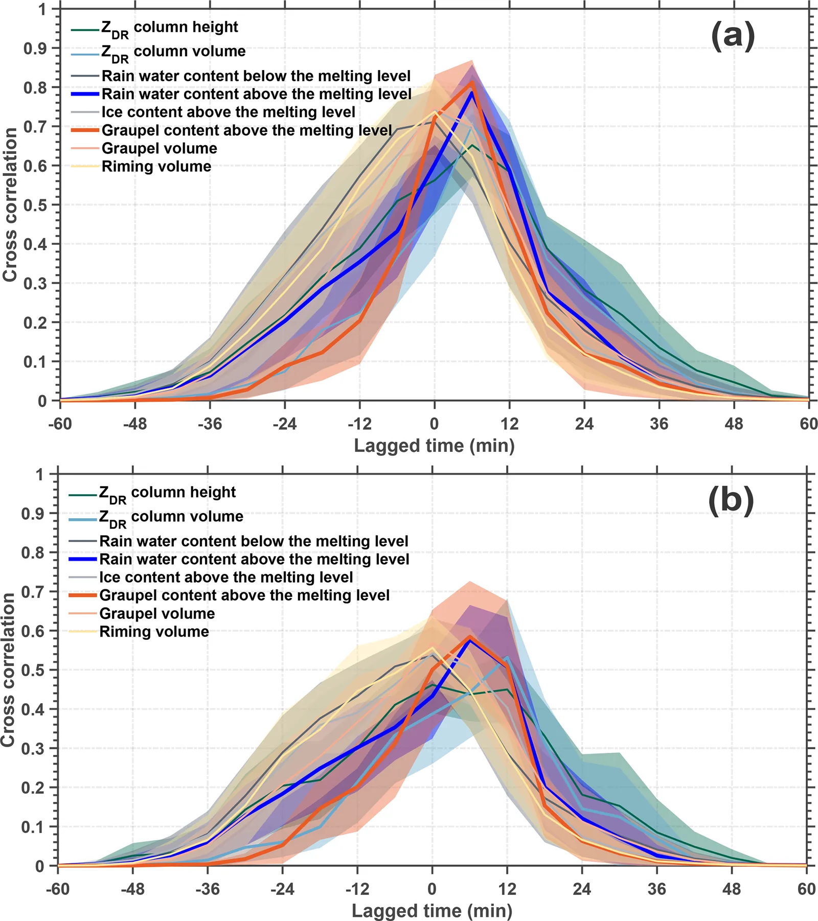
- Graupel content and rain water above the melting level predicted total flashes 6 minutes ahead with a correlation of approximately 0.8.
- ZDR column volume, ice content above the melting level and graupel volume reached approximately 0.7, and ZDR column volume looked better at a longer warning time of 12 minutes.
- For CG flashes, the 6-minute correlation for graupel and rain water above the melting level dropped to approximately 0.56.
- No lightning was seen without a ZDR column, and no KDP column appeared without a ZDR column. Some storms had no KDP column.
- In the case study, the ZDR column came first and collapsed inside the reflectivity core as graupel built up. A KDP column then appeared later, during heavy cold-cloud processes.
Limitations
- The melting level came from environmental soundings and was held constant, although it is often raised inside updraught cores. This biases the column estimates.
- Only small, isolated, subtropical storms were studied. Results may differ for supercells, mesoscale convective systems or tropical storms.
- Radar scans every 6 minutes, so the warning times are limited to 6 and 12 minutes. Autocorrelation may overstate the correlations by approximately 0.15.
Glossary
- ZDR column: A narrow vertical zone of high differential reflectivity above the melting level, caused by large supercooled raindrops lifted by an updraught.
- KDP column: A vertical zone of high specific differential phase above the melting level, linked to water-coated ice and many small raindrops.
- Graupel: Soft, rimed ice pellets that take part in the charging that produces lightning.
- Non-inductive charging: Charge transfer when ice particles such as graupel and ice crystals collide inside a storm.
Original paper
Bridging the polarimetric structure and lightning activity of isolated thunderstorm cells during the cloud life cycle
Atmospheric Chemistry and Physics · 22 October 2025
AI-generated summary of the original article; changes were made. Check the original before relying on it.