Multi-GPU model simulates a Berlin-wide flood at 5 m resolution in 34 minutes
With eight GPUs, the RIM2D flood model can simulate a 48-hour rainstorm over all of Berlin fast enough for early warning, at 10 m, 5 m and even 2 m resolution.
Why it matters
Berlin has no city-wide pluvial flood map or forecast model. Official maps cover only small catchments. This work shows that a physics-based model can cover the whole city quickly enough for forecasting. It could also support impact-based warnings and large ensembles of scenarios.
What they did
The authors ran the RIM2D flood model on a Berlin-wide elevation grid at 2, 5 and 10 m resolution, using 1 to 8 NVIDIA A100 GPUs. They simulated the June 2017 flood using radar rainfall and a 100-year, one-hour design storm. They did not calibrate the model. They checked the 2017 depths against 16 water marks taken from photos and videos posted by residents. They compared the design-storm results with the city’s official hazard maps in three catchments.
Key findings
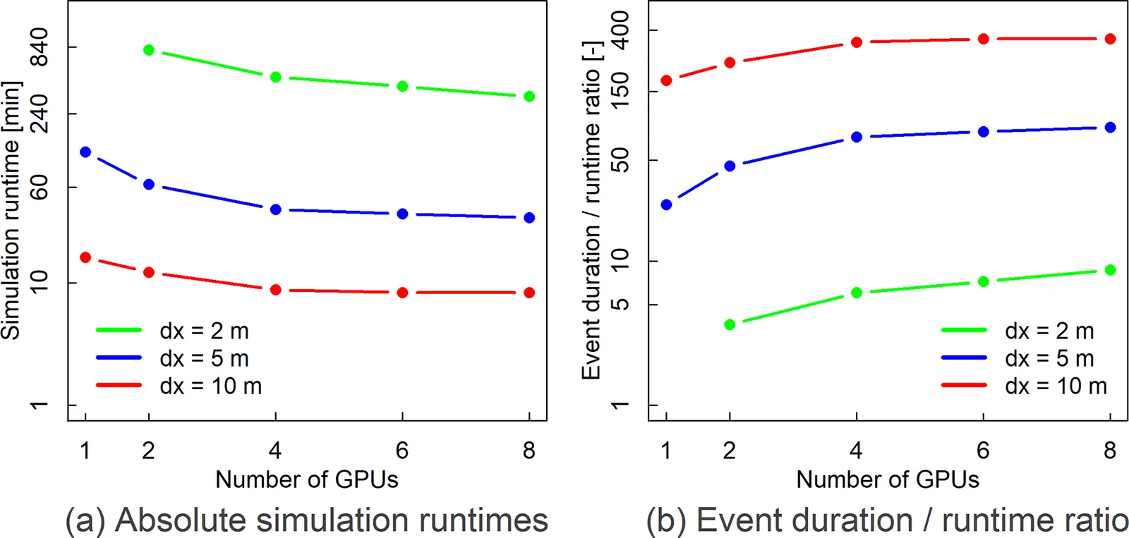
- The 48 h 2017 event ran in 8 min at 10 m, 34 min at 5 m, and 330 min (5.5 h) at 2 m using 8 GPUs.
- At 2 m resolution the domain was too large for a single GPU, and 1 m resolution would need more than 8 GPUs.
- Beyond 4 GPUs (5 and 10 m) or 6 GPUs (2 m), extra GPUs gave only small speed gains.
- The model tended to slightly underestimate depths at the water marks. One site was overestimated by about 40 cm, likely because of a missing hydraulic feature.
- For the 100-year storm, the model agreed strongly with official maps, and finer resolution improved skill only slightly. The whole city ran in under 30 min even at 2 m.
Limitations
- The model was not calibrated and had no detailed sewer network, underground structures, underpasses or bridges. Sewers were assumed empty at the start, with one uniform capacity.
- Validation for 2017 relied on photos and videos from residents at a small number of sites. No systematic observations existed.
- No full sensitivity study was done. The authors note that typical parameter uncertainty changes flooded area by ±10 %–20 % and depths by ±15 %–25 %.
Glossary
- RIM2D: A raster-based 2D flood model that runs on GPUs and solves a simplified form of the shallow water equations.
- HQ100: A 100-year return period flood scenario, used here for official hazard mapping.
- Volunteered geographic information (VGI): Location-tagged photos and videos shared by the public, used here to estimate flood depths.
- Pluvial flooding: Flooding caused by heavy rain overwhelming drainage, rather than by rivers overflowing.
Original paper
Enabling real-time high-resolution flood forecasting for the entire state of Berlin through multi-GPU accelerated physics-based modeling
Natural Hazards and Earth System Sciences · 13 January 2026
AI-generated summary of the original article; changes were made. Check the original before relying on it.