Argo floats and machine learning yield gridded Southern Ocean carbon maps to 5600 m
The authors used a neural network to turn Argo float temperature, salinity and sometimes oxygen into 1°×1° maps of Southern Ocean carbon chemistry, including anthropogenic carbon, with uncertainties.
Why it matters
Ship data in the Southern Ocean are sparse, and carbon-related measurements are even rarer. Most Argo floats lack oxygen sensors, so a method that works with or without oxygen makes far more float data usable. The free SOCOML products may support studies of Southern Ocean carbon uptake and ocean acidification.
What they did
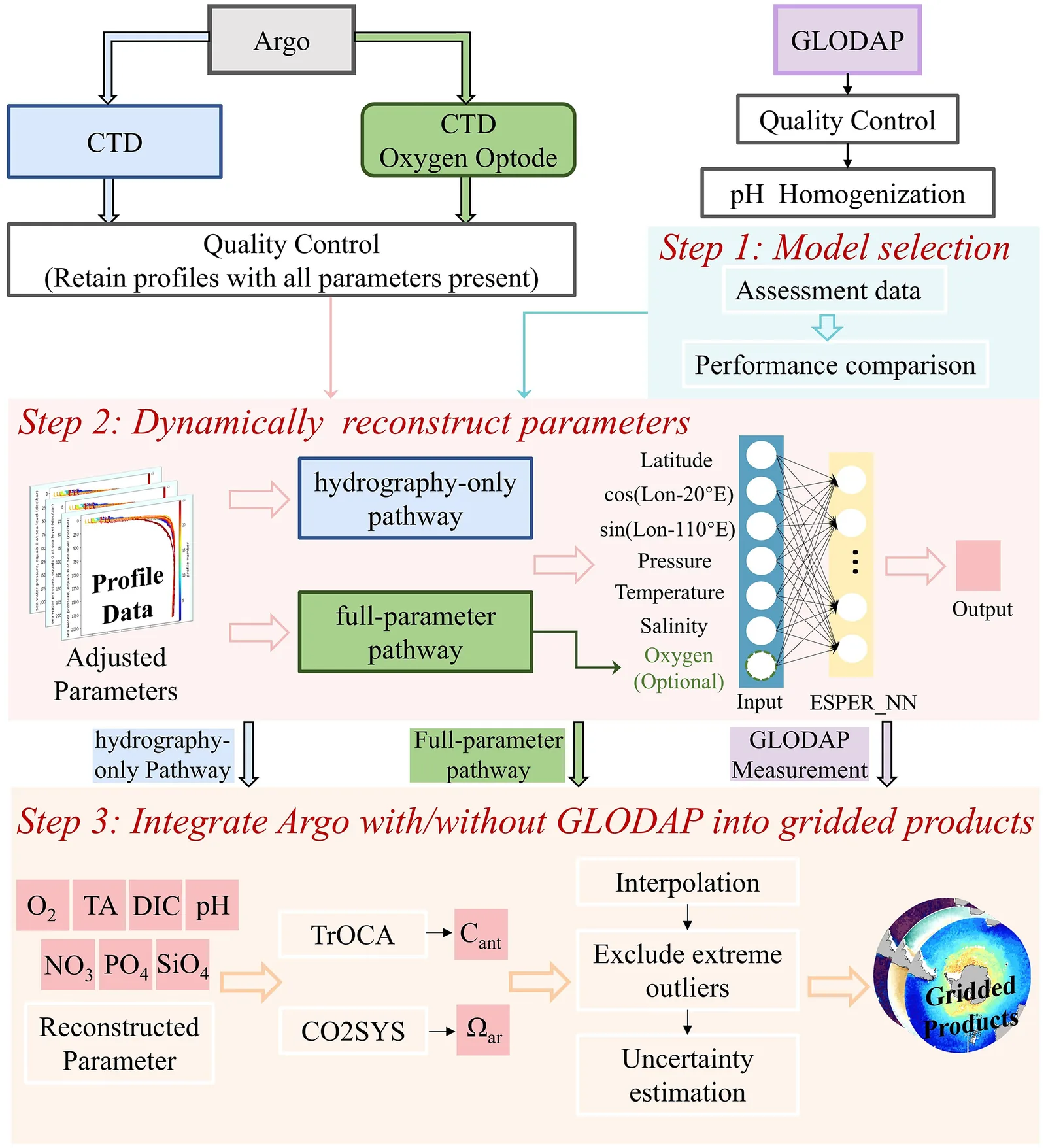
They compared three models (CANYON-B, ESPER_LIR, ESPER_NN) on independent ship data and chose ESPER_NN. They applied it to Argo float profiles by two routes: with measured oxygen, or with temperature, salinity and depth only. Anthropogenic carbon came from the TrOCA method and aragonite saturation from CO2SYS. They merged the results with GLODAP ship data into four 1°×1° grids with 84 depth levels, and estimated uncertainties by Monte Carlo simulation and weighted averaging.
Key findings
- ESPER_NN gave the lowest error for most variables, including TA (4.37 µmolkg-1) and DIC (6.09 µmolkg-1) when oxygen was used.
- Leaving out oxygen raised the DIC error to 8.78 µmolkg-1, especially in deep and abyssal waters.
- Anthropogenic carbon uncertainty is about ±4–6 µmolkg-1 for both routes. The two routes differ by within ±10 µmolkg-1 for anthropogenic carbon and ±0.075 for aragonite saturation.
- Maps show low anthropogenic carbon and high DIC south of the Polar Front, and higher values in the eastern Antarctic region where bottom water forms.
- Models appear to underestimate DIC increasingly over time, which leads to underestimated anthropogenic carbon, especially on the route without oxygen.
Limitations
- In the southwestern Atlantic the grid from floats without oxygen shows odd hotspots, likely from few ship training samples, so the authors advise the oxygen-float grid there.
- Models trained on a fixed period cannot capture emerging trends, and data south of 65° S and below 4000 m are very scarce.
- Mapping errors and some potential biases are hard to assess, and the uncertainty may be underestimated because of representativity error.
Glossary
- Anthropogenic carbon (Cant): The extra dissolved carbon in seawater that came from human CO2 emissions.
- Aragonite saturation (Ωar): A measure of how easily seawater can form or dissolve aragonite, a shell mineral. Lower values mean more acidification stress.
- ESPER_NN: A neural network that estimates seawater chemistry from temperature, salinity, depth, location and optionally oxygen.
- TrOCA: A method that estimates anthropogenic carbon from oxygen, DIC, alkalinity and temperature.
Original paper
Climatological fields of Southern Ocean interior carbonate system parameters and anthropogenic CO 2 reconstructed and integrated from float- and ship-based observations
Earth System Science Data · 15 December 2025
AI-generated summary of the original article; changes were made. Check the original before relying on it.