Diffusion model sharpens and bias-corrects climate model rain, keeping trends
A diffusion model trained only on ERA5 observations can turn coarse GFDL-ESM4 precipitation into sharp 0.25° fields with fewer extreme-rain biases than quantile mapping, while keeping the model's large-scale patterns and climate change signal.
Why it matters
Climate models are too coarse and too biased to use directly for flood and water planning. Quantile mapping fixes single-cell statistics but leaves rain fields blurry. This method gives detailed fields and better extremes, and one trained model can be applied to other climate models without retraining.
What they did
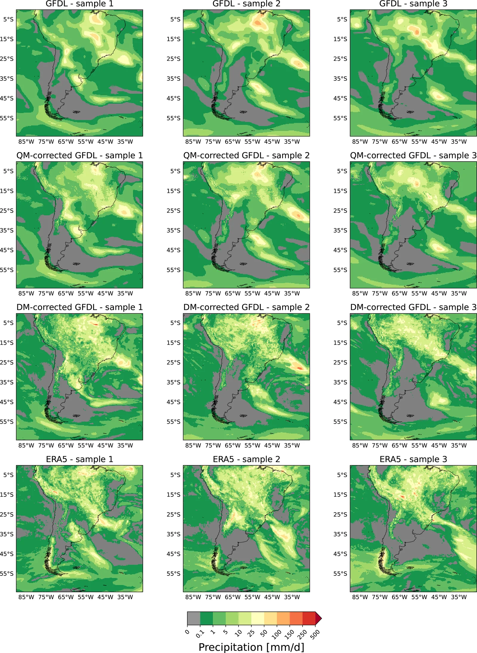
The authors treated bias correction and downscaling as one task. They added noise to both ERA5 and quantile-mapped GFDL-ESM4 daily precipitation until small-scale differences disappeared, which gave both a shared embedding space. They trained a conditional diffusion model on ERA5 alone to rebuild the sharp fields from the noised ones. At inference they fed it the noised GFDL fields. They tested over South America against a quantile-mapping benchmark, and also over South Asia, with the MPI-ESM-HR model, and under the SSP5-8.5 future scenario.
Key findings
- Power spectra of the corrected GFDL fields match ERA5 closely, while quantile-mapped fields stay too smooth and blurry.
- Mean absolute bias in the climatology fell from 0.69 mm d−1 for raw GFDL to 0.32 mm d−1 with the diffusion model. Quantile mapping reached 0.26 mm d−1.
- For events above 50 mm d−1 and above 80 mm d−1, raw GFDL had return periods of 3.33 and 4.60 years against 4.11 and 7.38 years in ERA5. The diffusion model gave 4.18 and 7.98 years.
- A 50-member ensemble had lower CRPS than a bilinear baseline (0.76 mm d−1 vs. 0.90 mm d−1), and its spread matched its error well.
- Under SSP5-8.5, the mean and extreme-rain change signals of the original GFDL data were preserved, with slightly stronger extreme increases in the northwest.
Limitations
- The model needs retraining for a new region. A different climate model may need a new noise-scale setting, which also means retraining.
- Only precipitation was tested, on regional domains. Global scale, multiple variables and full time consistency across all scales are left for future work.
- Rare extremes are limited by how often they appear in the training data, and sampling is slow.
Glossary
- Quantile mapping (QM): A statistical fix that adjusts each grid cell’s model rainfall distribution to match observed rainfall.
- Diffusion model: A neural network that learns to turn noise step by step into realistic images, here conditioned on a coarse field.
- Power spectral density (PSD): A measure of how much variability a field has at each spatial scale.
- CRPS: A score for probabilistic forecasts, where lower means the ensemble is closer to what happened.
Original paper
Conditional diffusion models for downscaling and bias correction of Earth system model precipitation
Geoscientific Model Development · 3 March 2026
AI-generated summary of the original article; changes were made. Check the original before relying on it.