Finer grid spacing improves day-6 forecasts of three weather forecast busts in ICON
In three cases where the IFS forecast failed, global ICON runs with grid spacing of 5 km or finer better captured storm-driven upper-level potential vorticity (PV) changes and gave better day-6 skill, though some events stayed hard to predict.
Why it matters
Forecast busts are episodes of abnormally low skill. The study links them to small-scale moist processes that coarse models represent poorly. It suggests kilometer-scale global models help most when strong, localized heating drives the flow. The authors also say the same weakness may matter for climate simulations of Rossby wave breaking.
What they did
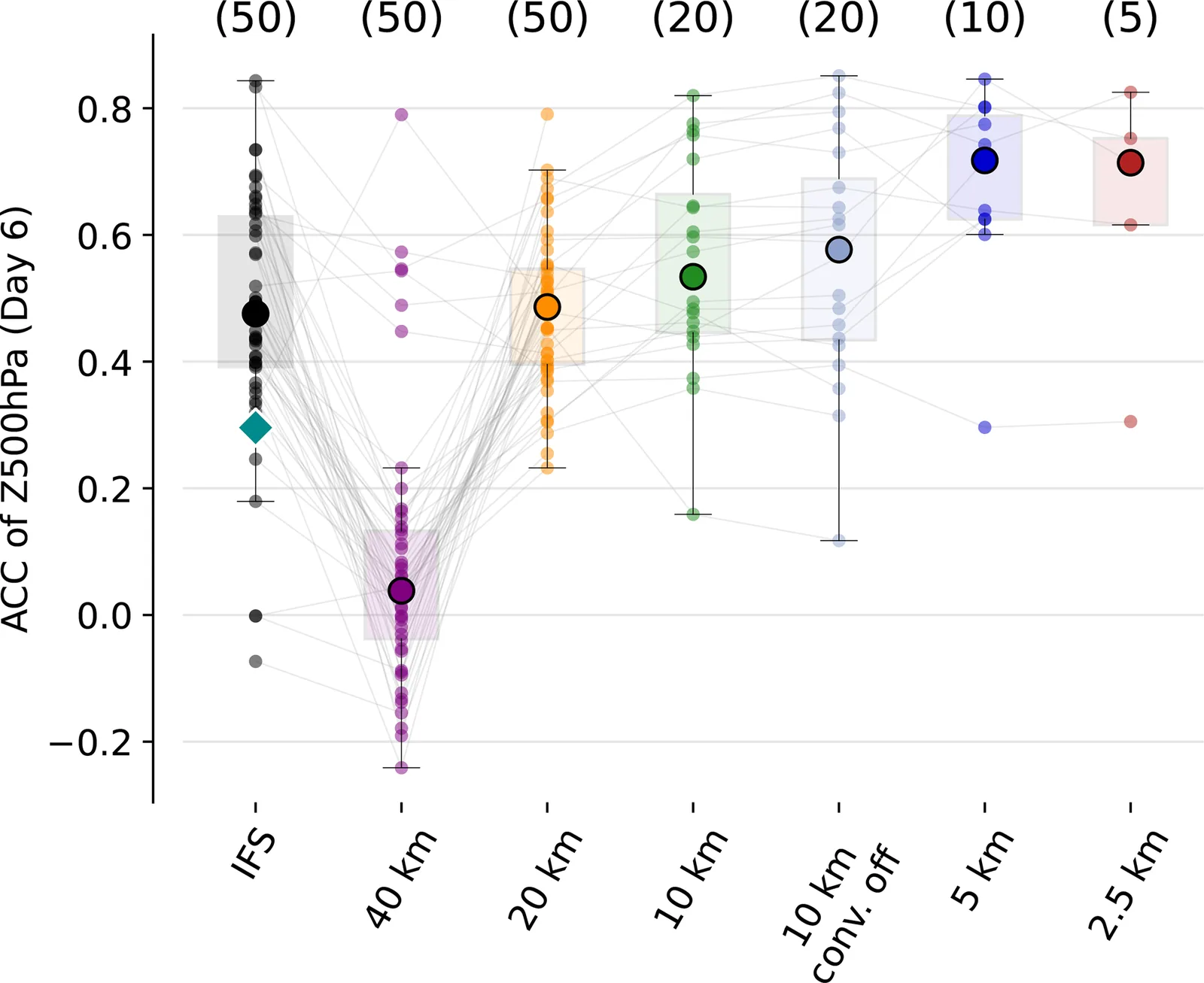
The authors picked three events that the IFS forecast busted: Storm Dennis in February 2020, a blocking event after Hurricane Franklin in September 2023, and a warm conveyor belt (WCB) ridge in June 2020. They started global ICON ensembles from IFS initial conditions with grid spacings of 40, 20, 10, 5 and 2.5 km. The ensembles had 50 members at 40 and 20 km and only 3 to 5 at 2.5 km. They compared 500 hPa height forecasts with ERA5 using the anomaly correlation coefficient (ACC). They also tracked negative PV, WCB ascent and cyclone paths.
Key findings
- In all three cases, the bust traced back to organized convection (a mesoscale convective system, a cyclone, or a WCB). Its latent heat release created negative PV aloft, which disturbed the jet stream and amplified downstream Rossby waves.
- Finer grid spacing gave larger negative PV areas, faster WCB ascent and more realistic heavy rain, closer to ERA5 and IMERG.
- Median day-6 ACC generally rose as grid spacing shrank, with the clearest gains at 5 km and finer. The 5 and 2.5 km runs differed little.
- Switching off deep convection parameterization at 10 km gave mixed results. It slightly helped in case 1 (ACC from 0.53 to 0.58) but hurt in case 2 (0.38 to 0.14) and case 3.
- The September 2023 blocking case stayed poorly predictable even at fine spacing, and initial conditions strongly shaped each member’s skill.
Limitations
- Only three cases were studied, so the authors say the results should be generalized with caution.
- The 2.5 km ensembles had only 3 to 5 members, which limits statistical robustness and significance tests.
- ERA5 is not fully independent of IFS, and the authors suggest the findings may not hold in tropical or sub-tropical regions.
Glossary
- Forecast bust: An episode of abnormally low forecast skill. Here it means ACC below 0.4 and RMSE above 60 m for 500 hPa height at 6 days.
- Anomaly correlation coefficient (ACC): A score of how well a forecast matches the observed pattern of departures from normal; higher is better.
- Potential vorticity (PV): A quantity describing air rotation and stability; latent heating aloft can create negative PV that reshapes the jet stream.
- Warm conveyor belt (WCB): A strongly rising airstream in an extratropical cyclone that carries moist air up to the upper troposphere.
Original paper
Grid-spacing sensitivity of Rossby wave breaking to mesoscale diabatic processes
Weather and Climate Dynamics · 20 October 2026
AI-generated summary of the original article; changes were made. Check the original before relying on it.