First global SWAT+ model runs at 2 km but river flow is weak without calibration
The CoSWAT framework makes a reproducible 2 km global SWAT+ model feasible, but without calibration or reservoirs it matches evapotranspiration reasonably and river flow poorly.
Why it matters
A global SWAT+ model could link water quantity, water quality and land management in one high-resolution tool. The open-source workflow lets others rebuild and extend the setup. The results show what must come next: calibration, reservoirs, irrigation and better snow handling.
What they did
The authors built CoSWAT, a Python workflow that downloads and prepares elevation, land use, soil and climate data and writes SWAT+ model files, using parallel processing. They set up the world as regions based on major river basins at 2 km resolution, giving 2.63 million HRUs. The model was run without calibration for 1977–1990 with a 5 year warm-up. They checked evapotranspiration against GLEAM v4 and monthly river discharge against GRDC gauge data.
Key findings
- Evapotranspiration maps from SWAT+ and GLEAM v4 had broadly similar spatial patterns for 1982–1990.
- 78.54 % of sampled points had evapotranspiration differences within ± 100 mm of GLEAM.
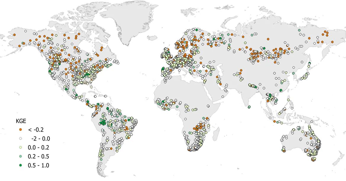
- Only 23.02 % of gauging stations had positive Kling–Gupta Efficiency for monthly river discharge.
- 85.31 % of stations showed positive correlation, and the median variability and bias ratios were close to 1.
- Setup took about 12 min for the Save Basin and about 1 h 49 min for the Nile Basin on a 64-core machine.
Limitations
- The model was not calibrated, and it has no reservoirs, irrigation or other water management, which hurt river flow results.
- Too much snow builds up at high latitudes and in mountains, and lakes are not represented, causing evapotranspiration artefacts; the 0.5° climate data is coarse.
- Evaluation of evapotranspiration is limited to one remote-sensing product, since eddy covariance data are scarce, and no direct comparison with other global models was made.
Glossary
- SWAT+: A water and land model that simulates water, sediment and nutrients over units called hydrologic response units.
- HRU (hydrologic response unit): A model unit with a unique mix of land use and soil within a subbasin.
- Kling–Gupta Efficiency (KGE): A score combining correlation, variability ratio and bias ratio between simulated and observed flow; values above 0 are the better range here.
- GLEAM: A dataset of evapotranspiration estimates used here as the reference.
Original paper
CoSWAT Model v1: A high-resolution global SWAT+ hydrological model
Hydrology and Earth System Sciences · 2 December 2025
AI-generated summary of the original article; changes were made. Check the original before relying on it.