Flood waves take about 17 months to travel from Lake Victoria to the Sudd
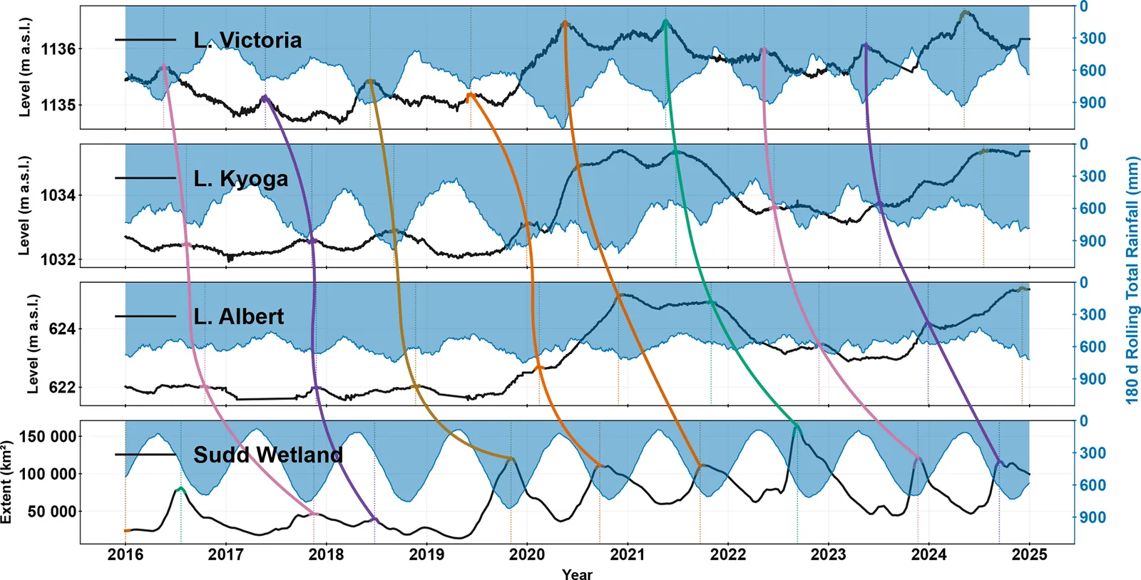
Tracking individual flood peaks shows the White Nile moves a Lake Victoria flood to the Sudd wetland in about 17 months, not the four to five months that seasonal timing suggests.
Why it matters
Flood warnings based only on rainfall or on short travel times can miss how long upstream storage keeps downstream wetlands flooded. The authors argue that forecasts for South Sudan should include lake levels, wetland extent before the rains, and connectivity. Flood planning thresholds may also need updating for back-to-back wet years.
What they did
The authors used daily lake levels and river discharge from Uganda and South Sudan, CHIRPS satellite rainfall, and MODIS-based flood maps of the Sudd for 2002–2024. They found each yearly Lake Victoria peak and followed it through Lakes Kyoga and Albert into the Sudd. Matching used peak size and shape, with manual checks. They also correlated Lake Victoria peaks with wetland extent at lags of 0–24 months across five South Sudan sub-catchments, and mapped how flooding persisted across the Sudd.
Key findings
- Mean system transit time from Lake Victoria to the Sudd was 16.84±1.95 months, with a range of 13.0–20.9 months.
- The Victoria–Kyoga reach was fast (mean 4.2 months), while the Albert–Sudd reach was slowest (mean 9.3 months), consistent with floodplain storage and backwater.
- Lake Victoria peaks of 1136.48, 1136.50 and 1136.66 m a.s.l. in 2020, 2021 and 2024 each exceeded the 1964 maximum of 1136.42 m a.s.l. The Sudd reached 163 475 km2 in 2022.
- After 2019, r2 between Lake Victoria peaks and downstream wetland extent exceeded 0.8 at 9–13-month lags in places. The authors say these lags show memory, not physical travel time.
- Flooding shifted from rainfall-driven activation in the eastern Sudd in 2019–2020 to inflow-driven, persistent flooding in the central and western Sudd in 2020–2022.
Limitations
- Lake Victoria outflow records are not public, MODIS maps show extent but not depth or volume, and vegetation can hide open water. Rainfall data are uncertain over South Sudan, where gauges are sparse.
- Sub-catchment borders in the flat Sudd are indicative only, and tracked transit times do not prove causation, especially where water spills both ways between sub-catchments.
- Current evidence cannot confirm a lasting regime change. Groundwater was not examined.
Glossary
- Flood-wave transit time: The time a flood peak takes to travel from one point in the river system to another, found by matching peaks.
- Backwater: High water downstream that slows outflow or pushes water back upstream, raising levels there.
- Hydrological memory: The way stored water from past seasons keeps shaping current flood conditions.
- Sudd: A very large, flat wetland in South Sudan on the White Nile.
Original paper
Lake Victoria to the Sudd Wetland: flood wave timing, connectivity and wetland buffering across the White Nile
Hydrology and Earth System Sciences · 20 August 2026
AI-generated summary of the original article; changes were made. Check the original before relying on it.