New global methane inventory for oil, gas and coal totals 74 Tg a−1 in 2020
GFEI v3 maps nationally reported 2020 fossil fuel methane emissions onto a 0.1° grid using new infrastructure and coal mine data, and it stays below other inventories and satellite-based estimates.
Why it matters
Satellite-based checks of national methane reports need a map of where emissions occur. GFEI v3 supplies that map, tied directly to UNFCCC reports, so any corrections can be traced back to the reports. Better placement of emissions also helps attribute them to the right sector, which guides mitigation.
What they did
The authors took national methane emissions reported to the UNFCCC as of September 2022 and filled gaps with IPCC Tier 1 estimates. They spread oil and gas emissions over a 0.1° × 0.1° grid using the OGIM infrastructure database and well data. For coal, they used Global Coal Mine Tracker locations and their own mine-level emission estimates based on mine depth and coal grade. They compared the result with v2, other inventories, and super-emitter plumes seen by the NASA EMIT instrument.
Key findings
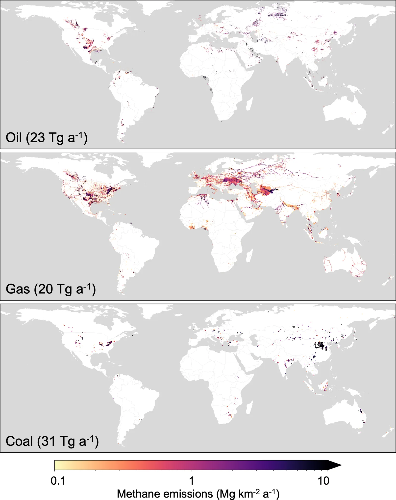
- Global emissions in 2020 are 23 Tg a−1 for oil, 20 Tg a−1 for gas and 31 Tg a−1 for coal, 74 Tg a−1 in total.
- This is lower than EDGAR (89 Tg a−1) and lower than v2 (80.4 Tg a−1), by 2–3 Tg a−1 per sector.
- Spatial patterns changed most in China, where coal emissions shifted from the south to the north because of the new mine database.
- EMIT super-emitters generally sit near infrastructure that GFEI v3 identifies, but their emission rates are poorly correlated with gridded emissions.
- In northeast China, detected oil-gas super-emitters fall in low-emission grid cells, possibly because of missing infrastructure.
Limitations
- Super-emitter measurements are sporadic and GFEI represents annual averages, so the comparison is imperfect.
- The conservative gridding that uses pipelines in place of missing infrastructure, and the use of well density, may misplace or underestimate emissions in some regions.
- Some countries do not report to the UNFCCC, and many non-Annex I reports are outdated, so estimates there rely on IPCC Tier 1 methods.
Glossary
- GFEI: Global Fuel Exploitation Inventory, a gridded map of methane emissions from oil, gas and coal.
- UNFCCC: The UN climate convention, to which countries submit national greenhouse gas reports.
- Super-emitter: A large point source of methane, often short-lived, seen by imaging satellites.
- Inverse modeling: Using atmospheric measurements to work backward and estimate emissions.
Original paper
Using new geospatial data and 2020 fossil fuel methane emissions for the Global Fuel Exploitation Inventory (GFEI) v3
Earth System Science Data · 10 December 2025
AI-generated summary of the original article; changes were made. Check the original before relying on it.