Open global dataset maps 2.75 billion buildings with heights from satellite images
Using only PlanetScope satellite images plus existing footprint data, the authors built the first complete global set of building outlines, 3 m height maps and simple 3D models, with height errors of 1.5 to 8.9 m by continent.
Why it matters
Building heights let analysts measure built space in volume, not only ground area. The dataset covers regions that lack height data, and the authors suggest volume per capita tracks development better than area per capita. The authors also estimate that the world has fewer buildings than the UN figure of 4 billion.
What they did
The team downloaded about 800 000 PlanetScope scenes, mostly from 2019, and trained deep networks to find building outlines and to estimate heights from single images. Heights were trained on aerial LiDAR from developed regions. They fused their own outlines with OpenStreetMap, Google, Microsoft and other footprint sources, choosing the best sources per region. They gave each building the maximum height inside its footprint, then tested the results against government 3D data from 28 cities and compared them with other products.
Key findings
- The dataset holds 2.75 billion buildings, with a total area of 506.64 billion m2 and a total volume of 2.85 trillion m3.
- The height map has 3 m resolution, 30 times finer than earlier global products at 90 m. Height RMSE ranges from 1.5 m in Oceania to 8.9 m in South America, and the global average is 5.5 m.
- The 3D building models cover more than 97 % of buildings with a height. They beat other products on volume error on every continent except South America.
- Africa has about 540 million buildings but only 117 billion m3 of volume, which points to small buildings. Asia has the most buildings and volume.
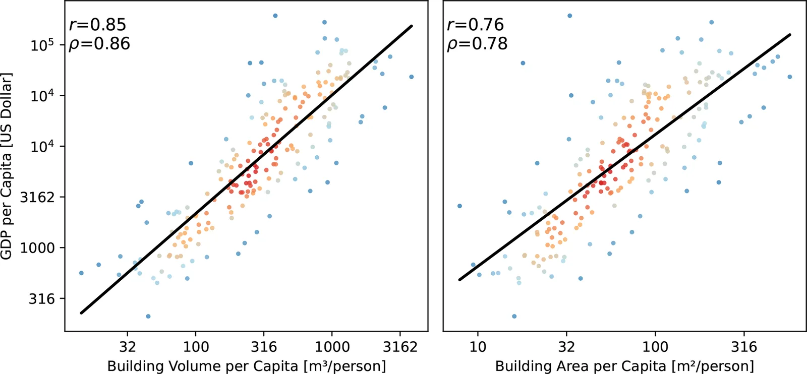
- Building volume per capita correlates better with GDP per capita (0.85) than building area per capita does (0.76). It also matched GDP rankings of country pairs more often (83.5 % versus 79.6 %).
Limitations
- The height model was not trained or checked on African data because no reference data exist there, so it may not transfer well to Africa.
- The model tends to underestimate heights in high-rise areas of some South American and Asian cities.
- The SDG 11.3.1 indicator itself could not be computed because no time series was available, so the volume-based indicator was tested only against GDP per capita.
Glossary
- LoD1: Level of Detail 1, a simple 3D building model made of a flat footprint extruded to a single height.
- RMSE: Root mean square error, a measure of the typical size of prediction errors, with big misses counting more.
- nDSM: Normalized digital surface model, a map of the height of objects above the ground.
- Monocular height estimation: Predicting height from a single image rather than from stereo pairs or laser scans.
Original paper
GlobalBuildingAtlas: an open global and complete dataset of building polygons, heights and LoD1 3D models
Earth System Science Data · 1 December 2025
AI-generated summary of the original article; changes were made. Check the original before relying on it.