Slush covers far more of Greenland's ice sheet than lakes, channels and crevasses combined
A nine-year satellite map shows slush is the largest mapped surface meltwater feature on the Greenland Ice Sheet, growing and reaching higher in high-melt years.
Why it matters
Slush has been largely left out of meltwater maps and of models of surface energy and water flow. It is much larger than other meltwater features, and a first-order estimate suggests it could add to melt if it darkens the surface. The authors argue that models should represent slush explicitly to better constrain future ice-sheet mass loss.
What they did
The authors adapted a machine-learning workflow built for Antarctic ice shelves. They trained a random forest classifier on Sentinel-2 images, using labels from k-means clustering reviewed by one expert. They mapped blue surface slush across the ice sheet for each melt season from 2016 to 2024. They then compared slush extent with modelled snowmelt, firn air content, snowfall and air temperature, and with ice slab and bare-ice maps. They also made a first-order estimate of extra melt from slush darkening.
Key findings
- Slush covered a mean seasonal extent of 2.8 % of the ice sheet (∼ 48 100 km2), from 1.1 % in 2018 to 5.1 % in 2019.
- In 2019, slush extent was about nine times the reported combined area of lakes, channels and water-filled crevasses.
- Slush was most extensive in the southwestern and northern basins and most persistent in the northern and northeastern basins. About 71 % of it lay over bare ice, and roughly 30 % overlapped ice slabs.
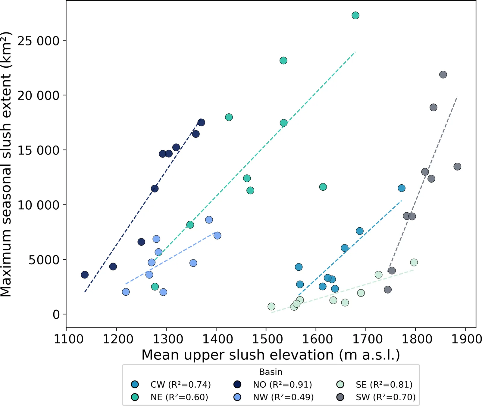
- Slush extent and upper elevation rose together in high-melt years. Extent was linked to higher snowmelt and lower firn air content. No ice-sheet-wide trend appeared over nine years.
- If the extra absorbed energy fully became melt, slush could add a mean of 12.4 Gt yr−1.
Limitations
- Training labels came from one analyst, and the classes are a simplification of a continuous change. The validation is internal, so it does not capture all sources of error.
- The melt estimate is first-order. Its coefficient came from open meltwater ponds and has not been validated for slush.
- The record is only nine years long, and the correlations rest on nine annual points per basin (eight for firn air content). Ice slab and firn datasets come from different periods. Comparisons with lake and channel studies use different methods.
Glossary
- Slush: Snow or firn that is saturated with water; here only the blue slush visible at the surface in satellite images.
- Firn air content (FAC): The air-filled pore space in firn, which measures how much meltwater it can store.
- Ice slab: A thick, low-permeability layer of refrozen ice near the surface that blocks meltwater from draining downward.
- Random forest: A machine-learning method that combines many decision trees and classifies by majority vote.
Original paper
A nine-year record of slush on the Greenland Ice Sheet
The Cryosphere · 7 August 2026
AI-generated summary of the original article; changes were made. Check the original before relying on it.