Soil salt area in a dry Chinese river basin held steady while salt severity rose
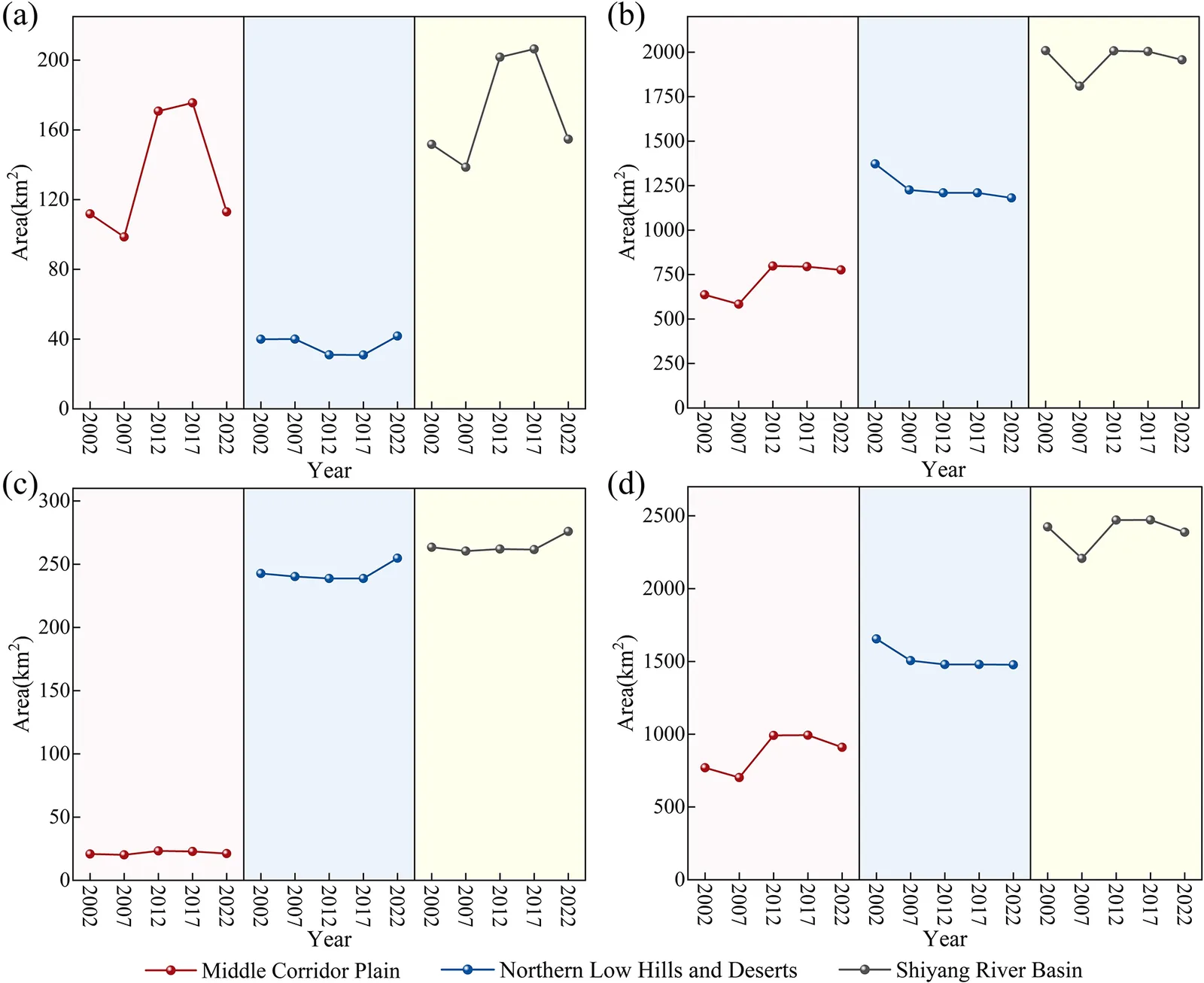
Satellite maps of the Shiyang River basin from 2002 to 2022 show the salty area changed little overall, but salinization got more severe near reservoirs, irrigated land and downstream water-input zones.
Why it matters
Salty soil harms crops and land in dry inland basins. The study links salt patterns to how people move and use water, such as reservoirs, irrigation and ecological water transfer. The authors say better water management could help reduce salinization.
What they did
The authors mapped soil salinization in the Shiyang River basin for 2002, 2007, 2012, 2017 and 2022 using Landsat satellite images, land use data and a support vector machine classifier. They checked the maps against 11 field soil samples, 92 points from a FAO soil database, and a field experiment in Gulang County. They then compared salt patterns with reservoir growth, irrigation area and irrigation districts.
Key findings
- Salinization grew from upstream to downstream, and was worst near Qingtu Lake. The southern Qilian Mountains showed no salinization.
- In the central corridor plain, salinized area rose, mostly moderate salinization. Compared with 2002, the 2022 area was up by over 18 %.
- In the northern hills and oasis–desert transition zone, total salinized area fell on average by 38.19 km2 per year. Severe salinization rose again from 2017 to 2022.
- Salinization around Hongyashan Reservoir intensified from 2002 to 2022. Groundwater electrical conductivity there rose by 14.119 µs cm−1 from 2017 to 2023.
- In the short term, more irrigation went with less salinized area, probably through leaching. Over the long term, salinized land sits mostly inside irrigation areas.
Limitations
- Landsat has low spectral resolution, atmospheric correction problems and a 16 d revisit cycle. Mild salinization was identified less well than other classes.
- Soil salinity monitoring began only in 2019, so the long-term maps could not be checked against long-term soil measurements.
- Soil salinization depends on several interacting factors, and satellite data from a single source cannot fully capture them.
Glossary
- Soil salinization: Buildup of salts in surface soil, often when water evaporates and leaves salt behind.
- Secondary salinization: Salinization caused by human activities such as irrigation, rather than by natural factors.
- Electrical conductivity: A measure of how well a soil or water sample conducts electricity, used as a sign of salt content.
- Support vector machine: A machine learning method that sorts data points into classes, used here to sort land into salinity levels.
Original paper
Soil salinity patterns reveal changes in the water cycle of inland river basins in arid zones
Hydrology and Earth System Sciences · 9 October 2025
AI-generated summary of the original article; changes were made. Check the original before relying on it.