Streamlined bed landforms found under slow ice at the start of the NE Greenland Ice Stream
Swath radar shows long, streamlined bed ridges (mega-scale glacial lineations) beneath ice moving only about 60 m per year near the Northeast Greenland Ice Stream onset, which challenges the idea that they need fast flow.
Why it matters
Mega-scale glacial lineations are often used as signs of fast ice streaming, both today and in past ice sheets. Finding them under slow ice so far inland may mean this rule needs a re-check. The bed map also hints that the ice stream was once wider, which matters for models that struggle to reproduce this ice stream.
What they did
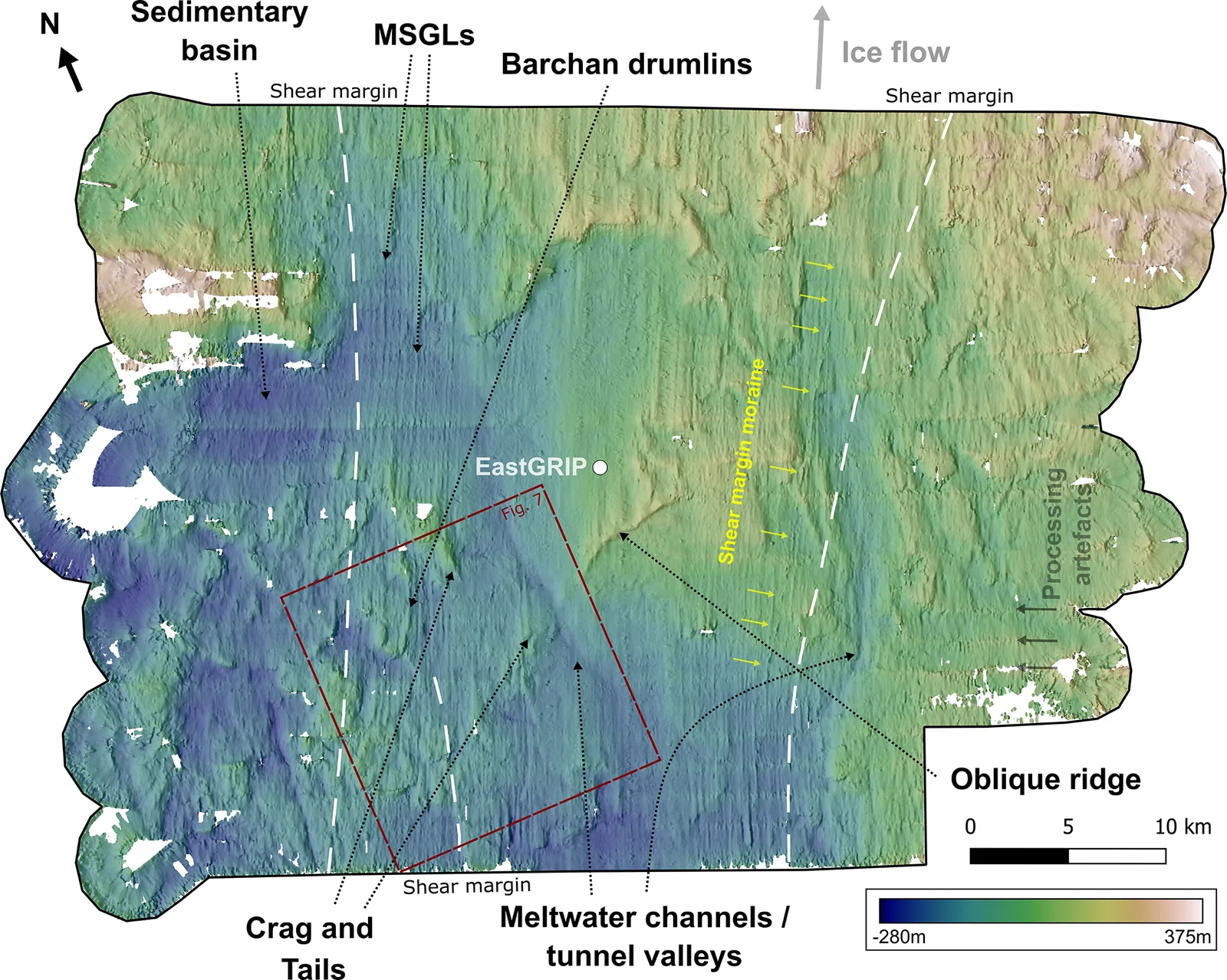
The authors processed airborne ultra-wideband radar data from 2018 and 2022 around the EastGRIP ice core site. A multi-antenna array and the MUSIC algorithm gave a bed elevation map of 25 m horizontal resolution and about 10 m vertical resolution, covering 40 × 60 km2. They mapped landforms by hand. They used hillshades and contours, then interpreted them using appearance (rough or smooth), relief, position relative to the shear margins, surface velocity and earlier seismic data on sediment.
Key findings
- Low-relief, elongated lineations are interpreted as mega-scale glacial lineations. Their elongation ratios range from 7.7 : 1 to 59.2 : 1, and they lie almost entirely inside the modern shear margins.
- The lineations have a mean height of 66.5 m and a mean length of 3025 m, under surface ice speeds that peak at 58 m yr−1.
- The bed looks like a mixed bed: rough bedrock features such as crag and tails sit next to smoother sediment basins and lineations. Large channels were also mapped.
- Crag and tails outside the present shear margins are about as elongated as those inside. The authors propose the ice stream may have been up to 10 km wider in the past.
- The authors favour formation in place under today’s slow flow within the roughly 2000 years of the current configuration. They cannot rule out preservation from an earlier faster phase.
Limitations
- Where no seismic data lie over the suspected bedrock areas, the bedrock interpretation is more uncertain.
- Swath edge artefacts (upwarping) can create false ridges and break up features, so only clear landforms crossing multiple swaths were mapped.
- The data are a single snapshot, so they cannot show whether the lineations are relicts or still forming. The authors say repeat surveys are needed.
Glossary
- Mega-scale glacial lineations (MSGLs): Very long, narrow, flow-parallel ridges on an ice stream bed, usually linked to fast flow.
- Swath radar: Radar processing that estimates where echoes come from across the flight track, so it maps a strip of bed instead of a single line.
- Shear margin: The edge zone where fast ice stream flow meets slower ice beside it.
- Crag and tail: An elongated landform with a bedrock knob upstream and a tapering tail of sediment downstream.
Original paper
Formation of mega-scale glacial lineations far inland beneath the onset of the Northeast Greenland Ice Stream
The Cryosphere · 30 October 2025
AI-generated summary of the original article; changes were made. Check the original before relying on it.