Two km-scale Earth system models ran 30-year climate simulations at about 500 days per day
The nextGEMS project got two km-scale Earth system models, ICON and IFS-FESOM, to run energetically consistent 30-year simulations for 2020–2049, though biases remain in the western Pacific.
Why it matters
Multidecadal simulations that resolve km-scale processes in atmosphere, land and ocean were out of reach until now. The work lays the base for the Climate Change Adaptation Digital Twin of Destination Earth. The authors also report that many model tests need only about a year of simulation, or even 12 days for radiation tuning, so more groups can afford to test km-scale models.
What they did
The project ran four development cycles from October 2021 to March 2024. Each cycle released new ICON and IFS-FESOM configurations, which more than 100 participants evaluated at a hackathon. The team fixed energy and water leaks, tuned cloud properties, and improved input/output and data sharing. The final simulations ran 30 years under the SSP3-7.0 scenario. They used a 10 km atmosphere and a 5 km ocean, and were compared with satellite and gridded observations.
Key findings
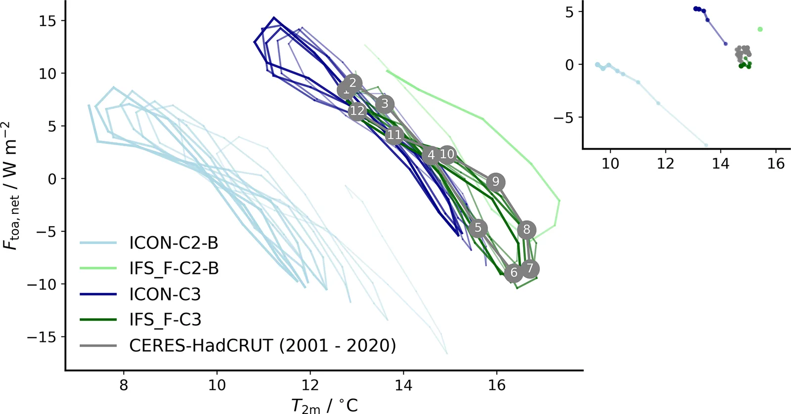
- Early runs had large energy and water imbalances. Cycle 1 ICON had a drift of about -2 K, and IFS-FESOM had a 4.6 % spurious rise in precipitation. By Cycle 4 both models had an energetically consistent climate.
- Throughput rose from about 10 simulated days per day to 414 for ICON on 464 nodes and 600 for IFS-FESOM on 269 nodes.
- IFS-FESOM matched observed 2 m temperature and top-of-atmosphere radiation better than ICON. Averaged over 2020 to 2023, the temperatures were 14.94°C for IFS-FESOM, 13.83°C for ICON and 14.91°C for HadCRUT.
- Both models reproduced the tropical rainbelt over land and the eastern Pacific. In the western Pacific, ICON shows a double ITCZ bias and precipitation 7 mm d−1 too low at the equator. IFS-FESOM is 3 mm d−1 too low.
- ICON matched the annual cycle of Californian stratocumulus clouds better than IFS-FESOM. IFS-FESOM captured blocking frequency better.
Limitations
- The 10 km atmospheric grid was a compromise forced by limited computing resources. A 10 km grid does not remove biases in the western Pacific.
- The authors say robust answers to their four questions will only come from later separate studies. They also say a causal link between global climate and regional patterns cannot be proven.
- The simulations ran without carbon cycle or aerosol modules, and some comparisons use observation periods that barely overlap the simulated years.
Glossary
- km-scale model: A model with horizontal grid spacing of 10 km or finer, so storms and ocean eddies are resolved rather than parameterized.
- Energetically consistent climate: A near-stationary climate with top-of-atmosphere energy balance near zero, conserved mass and energy, and no near-surface temperature drift.
- SDPD: Simulated days per day, a measure of how fast a model runs.
- Double ITCZ: A model error in which the tropical rain band splits into two bands near the equator.
Original paper
nextGEMS: entering the era of kilometer-scale Earth system modeling
Geoscientific Model Development · 23 October 2025
AI-generated summary of the original article; changes were made. Check the original before relying on it.