Two Sentinel-2 satellites flown in tandem image ocean surface currents at 1 km resolution
Two optical satellites flying 27 s apart can track short wind waves and so map surface currents at 1 km scale, showing fine-scale divergence that altimetry misses.
Why it matters
Small ocean currents and their vertical motions are thought to move heat, carbon and nutrients, but satellites could not see them directly. This method gives a reference measurement to test models and other satellite products. The authors say a dedicated mission could extend it.
What they did
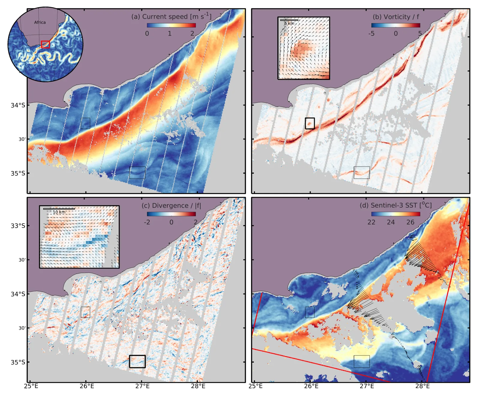
The team used Sentinel-2 satellites that flew in tandem on the same orbit, about 27.4 s apart, during calibration phases. They tracked the shift in phase of many wind-wave components between the two images. Removing the known wave speed leaves the current. They checked results against swath altimetry, HF radar, drifters, and temperature and radar-roughness fronts. They studied the Agulhas, Somalia, Galapagos and Madagascar regions.
Key findings
- Currents are retrieved at 1 km resolution. Internal estimates suggest a precision of around 1 cm s −1, and comparison with other instruments suggests accuracy better than 20 cm s−1 per component.
- In the Agulhas, 80% of the strongest current fronts lie within 3 km of a temperature front, against 18% expected by chance.
- Divergence is concentrated at scales below 5 km, which hold 90% of its variance.
- Off Somalia, the retrieved divergence matched SWOT radar roughness with a correlation of 0.75 and revealed a field full of internal waves.
- Off Madagascar, a coastal jet reached 1.1 m s−1. Traditional altimetry underestimates it by 70%, and the latest SWOT data by 60% locally.
- The Agulhas core looked smoother and had weaker 1-10 km variability than some models and airborne radar suggest.
Limitations
- The method needs cloud-free scenes, enough wind waves (wind above about 5 to 6 m s−1) and high Sun. Tandem data came only from calibration phases.
- No coincident kilometre-scale current measurements exist for direct verification. Co-registration errors affect absolute currents, and vertical shear was not considered.
- This is a preprint under review and has not been peer reviewed.
Glossary
- Submesoscale: Ocean motions about 1-50 km wide, too small for conventional altimeters to resolve.
- Geostrophic balance: A balance between the pressure gradient and the Coriolis force, so sea-surface height mirrors the current.
- Divergence: How much surface water spreads apart or converges, linked to vertical exchange with deeper water.
- Internal waves: Waves inside the ocean that move along density layers and leave marks on the surface.
Original paper
Ocean surface currents directly imaged from space
EarthArXiv · 24 September 2026
This paper is a preprint. It has not been peer reviewed, and its results may change.
AI-generated summary of the original article; changes were made. Check the original before relying on it.