Central Pacific El Niño winters make North Atlantic Oscillation forecasts more skilful
In winters with a Central Pacific El Niño, seasonal forecasts of the North Atlantic Oscillation are much more skilful, probably because Aleutian-region ocean warmth feeds a link to the Atlantic.
Why it matters
The North Atlantic Oscillation shapes winter weather across Europe and North America, but it is hard to forecast months ahead. Knowing when forecasts are likely to work better can help users judge how far to trust a seasonal outlook. The results also point to ENSO asymmetries as something forecast models need to represent better.
What they did
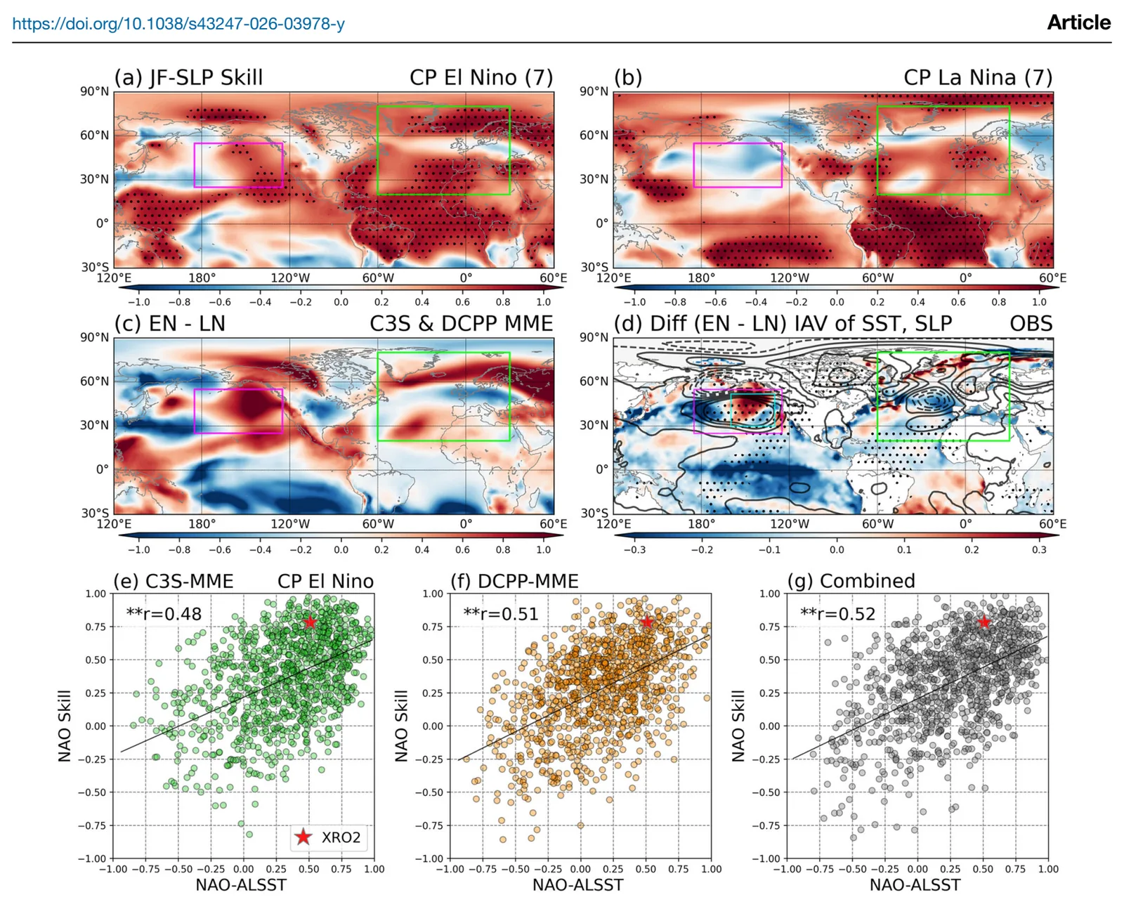
The authors tested January–February NAO forecasts from eight C3S seasonal systems, six decadal-prediction systems, and a reduced-order model called XRO2. They split winters into Central Pacific El Niño and La Niña years. They used reanalysis and CESM2 Pacemaker runs, in which observed tropical Pacific sea surface temperatures are imposed, to trace the physical pathway. They then used 30 CMIP6 models, plus a 100-member large ensemble, to look at future changes under warming.
Key findings
- NAO forecast skill was much higher in Central Pacific El Niño winters (r = 0.78 for C3S, r = 0.51 for DCPP, r = 0.62 for XRO2). In Central Pacific La Niña winters it was not significant.
- During Central Pacific El Niño, Aleutian sea surface temperature variability rises, storm tracks shift poleward from the northeast Pacific into the Atlantic, and an NAO-like pattern follows. Models with stronger coupling between the Aleutian ocean and the NAO had higher NAO skill.
- El Niño of this type does not reliably push the NAO into a negative phase. It mainly raises NAO variability and the predictable signal.
- The signal-to-noise paradox grows in these winters: the ratio of predictable components rises to 3.04 in C3S and 2.32 in DCPP.
- CMIP6 models project a significant rise in how often Central Pacific El Niño occurs under SSP5-8.5. They show no significant change in its variance.
Limitations
- Few events underlie the composites (for example 7 El Niño years in the C3S period), and the NAO variance contrast was only marginally significant (p = 0.13).
- Future changes in Central Pacific ENSO strength differ widely between models, so confidence in future changes to the teleconnection is limited.
- CMIP6 models greatly underestimate the observed Aleutian-SST–NAO correlation. The Pacemaker model underestimates the observed variance contrast.
Glossary
- North Atlantic Oscillation (NAO): A seesaw in air pressure between Iceland and the Azores that steers winter weather over the North Atlantic region.
- Signal-to-noise paradox: The real atmosphere appears more predictable than model ensembles imply.
- Pacemaker experiment: A climate model run in which observed tropical Pacific sea surface temperatures are imposed so that the rest of the model responds.
- Anomaly correlation coefficient (ACC): A measure of how well forecast departures from normal match observed departures over time.
Original paper
Central Pacific El Niño-driven Pacific–Atlantic teleconnections are an important source of North Atlantic Oscillation predictability
Communications Earth & Environment · 27 August 2026
AI-generated summary of the original article; changes were made. Check the original before relying on it.