Daily-resolution glacier modelling projects more ice loss and sea-level rise than monthly
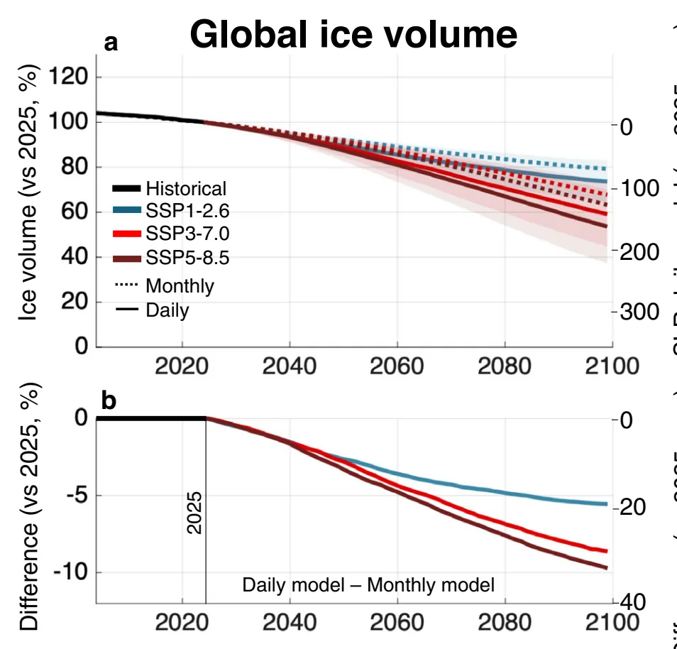
A global glacier model run with daily weather instead of monthly averages projects 5-10% more ice loss by 2100, adding 20-33 mm of sea-level rise.
Why it matters
Most global glacier projections use monthly weather data. This study suggests they may systematically underestimate future glacier loss. Daily resolution also gives runoff timing and variability that hydrological and land-surface models need.
What they did
The authors built a daily-resolution version of the Global Glacier Evolution Model (GloGEM) and ran it next to the standard monthly version. They simulated all glaciers larger than 5 km2 from 2025 to 2100. They used five climate models and three emission scenarios. Both versions were calibrated against glacier-specific geodetic mass balances, with shared precipitation and temperature corrections so that differences reflect time resolution. They checked results against 4037 annual in situ mass-balance observations and regional estimates.
Key findings
- The daily model fits observed mass balance slightly better. RMSE falls from 0.63 to 0.61 m w.e. and R2 rises from 0.71 to 0.75. The gain is larger in extreme years, where RMSE falls from 0.98 to 0.83 m w.e.
- Globally, the daily model projects ice losses of 26 ± 10% (SSP1-2.6) and 47 ± 17% (SSP5-8.5) over 2025-2100. That is 5-10% more loss than the monthly model by 2100.
- By 2100 the daily model’s extra glacier contribution to sea-level rise is 20-33 mm. It sits within the spread between climate models.
- The gap is largest in low-relief, ice-cap regions such as Svalbard, with 20-25% more relative loss by 2100. Iceland is reversed, with 4% less loss in the daily model because more precipitation falls as rain.
- The daily model shows runoff timing shifts that the monthly model misses. In Western Canada and the USA, peak runoff comes about 46 days earlier by 2100.
Limitations
- The polar and subpolar differences, especially Svalbard and the Russian Arctic, depend on calibration choices and should be read as upper-end estimates.
- Only glaciers larger than 5 km2 are simulated. Future climate data were bias-corrected with a delta method that does not adjust daily variability. Runoff is assumed to leave the glacier at once, with no routing.
- The daily model takes about ten times longer to run, and runoff composition estimates are model diagnostics that were not validated.
Glossary
- Temperature-index model: A glacier melt model that links melt to air temperature through degree-day factors, instead of computing the full energy balance.
- m w.e.: Metres of water equivalent, a unit for glacier mass change expressed as the depth of water the ice or snow would make.
- GloGEM: The Global Glacier Evolution Model, which simulates glacier mass balance, runoff and volume change.
- Precipitation phase: Whether precipitation falls as snow or rain, which depends on air temperature.
Original paper
Resolving short-term meteorological variability amplifies projected glacier loss and sea-level rise
Nature Communications · 19 October 2026
AI-generated summary of the original article; changes were made. Check the original before relying on it.