Melting grounding zones let a model match Thwaites' retreat and double its sea-level share
When an ice-sheet model lets seawater melt ice several kilometers inland of the grounding line, it matches 27 years of Thwaites observations and projects about twice the earlier sea-level contribution by 2100.
Why it matters
Thwaites is a major source of uncertainty in future sea-level rise. The study suggests that how models treat the grounded-to-floating transition changes projections a lot. The authors argue that actively melting grounding zones should be included in regional and continental ice-sheet models.
What they did
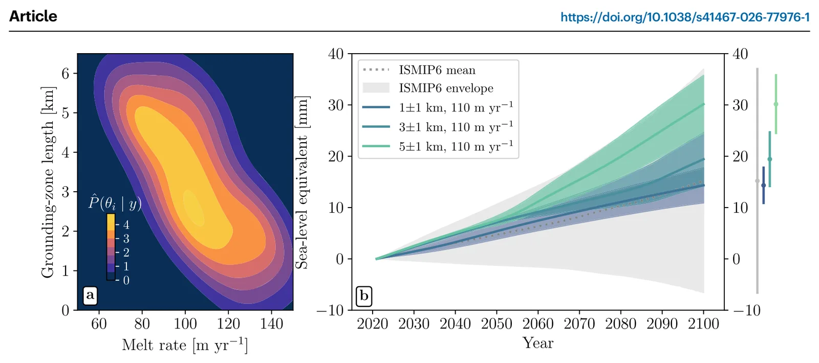
The team used the Ice-sheet and Sea-level System Model (ISSM) and added a grounding zone, where seawater melts ice inland of the flotation line. They ran 105 simulations that varied the melt rate and the grounding-zone length, starting from a 1990s state. A Bayesian calibration compared the runs with satellite records of speed, thickness change and grounding-line position from 1996 to 2023. They then ran the model to 2100 under constant climate forcing.
Key findings
- Only grounding zones 2-5 km wide, with melt rates of 90-120 m per year, reproduced the observed retreat, thinning and speed-up together.
- Runs without a grounding zone were four times less likely to match the historical trend than runs with a grounding zone of a few kilometers.
- Whether the glacier detaches from Mouginot Ridge depends on grounding-zone length. Runs with no zone or a 1 km zone did not retreat past the ridge by 2100, and runs with a 5-6 km zone unpinned as early as 2038.
- At a melt rate of 110 m per year, projected sea-level contribution by 2100 was 8.3 ± 3.0 mm with no grounding zone, 19.4 ± 5.2 mm with a 3 km zone and 30.1 ± 5.7 mm with a 5 km zone.
- The 5 km result is twice the ISMIP6 mean of 15.2 ± 21.8 mm under the same constant forcing.
Limitations
- Grounding-zone length is held fixed in time, though in reality it likely varies with bed slope, tides and subglacial water pressure.
- The ice front is fixed, so calving is excluded. Melt comes from a simple depth-based formula rather than a coupled ocean model, and basal friction is not reduced by seawater lubrication.
- Projections assume constant climate forcing, and the model needed a 100 m lift of the sea floor under floating ice to match the 1996 grounding line.
Glossary
- Grounding zone: The stretch where seawater slips under grounded ice, often only during tides, instead of a sharp line between grounded and floating ice.
- Grounding line: The place where ice resting on the sea floor starts to float.
- mCDW: Modified Circumpolar Deep Water, a warm ocean water that melts the underside of Antarctic ice.
- ISMIP6: An intercomparison project that gathers ice-sheet model projections from many models.
Original paper
Sea-level contribution from Thwaites Glacier doubles in an observation-constrained ice-sheet model
Nature Communications · 12 October 2026
AI-generated summary of the original article; changes were made. Check the original before relying on it.