Ice falling into a supercooled stratus layer boosted precipitation in a Swiss case
On 8 January 2024 over the Swiss Plateau, ice crystals from an upper cloud fell into a low supercooled liquid cloud, rimed heavily and raised surface precipitation, which the operational ICON-D2 model seemed to underestimate.
Why it matters
Mixed-phase clouds produce much of mid-latitude precipitation, and weather models struggle to get their ice-liquid balance right. This detailed case shows which processes a model must capture. The authors argue that better handling of supercooled liquid water could improve forecasts where low stratus is common.
What they did
The authors studied one event on 8 January 2024 at Eriswil, Switzerland. They combined radar, lidar, microwave radiometer, ground-based particle sensors and ICON-D2 forecasts. They tracked fall streaks of ice from cloud top to the ground. They also applied retrievals for liquid water, riming, particle shape, turbulence and Doppler peaks.
Key findings
- Strong seeding coincided with more surface precipitation. With no seeding, precipitation was little to none.
- The low Bise stratus stayed liquid with almost no ice of its own. Seeded ice rimed there, with a rimed mass fraction above 70 % in the radar retrieval.
- Ground sensors showed a rimed mass fraction of around 90 %, and ice crystal numbers were higher during seeding.
- Ice fall speed rose from around -0.8 m s−1 to around -1.6 m s−1 once crystals entered the feeder cloud.
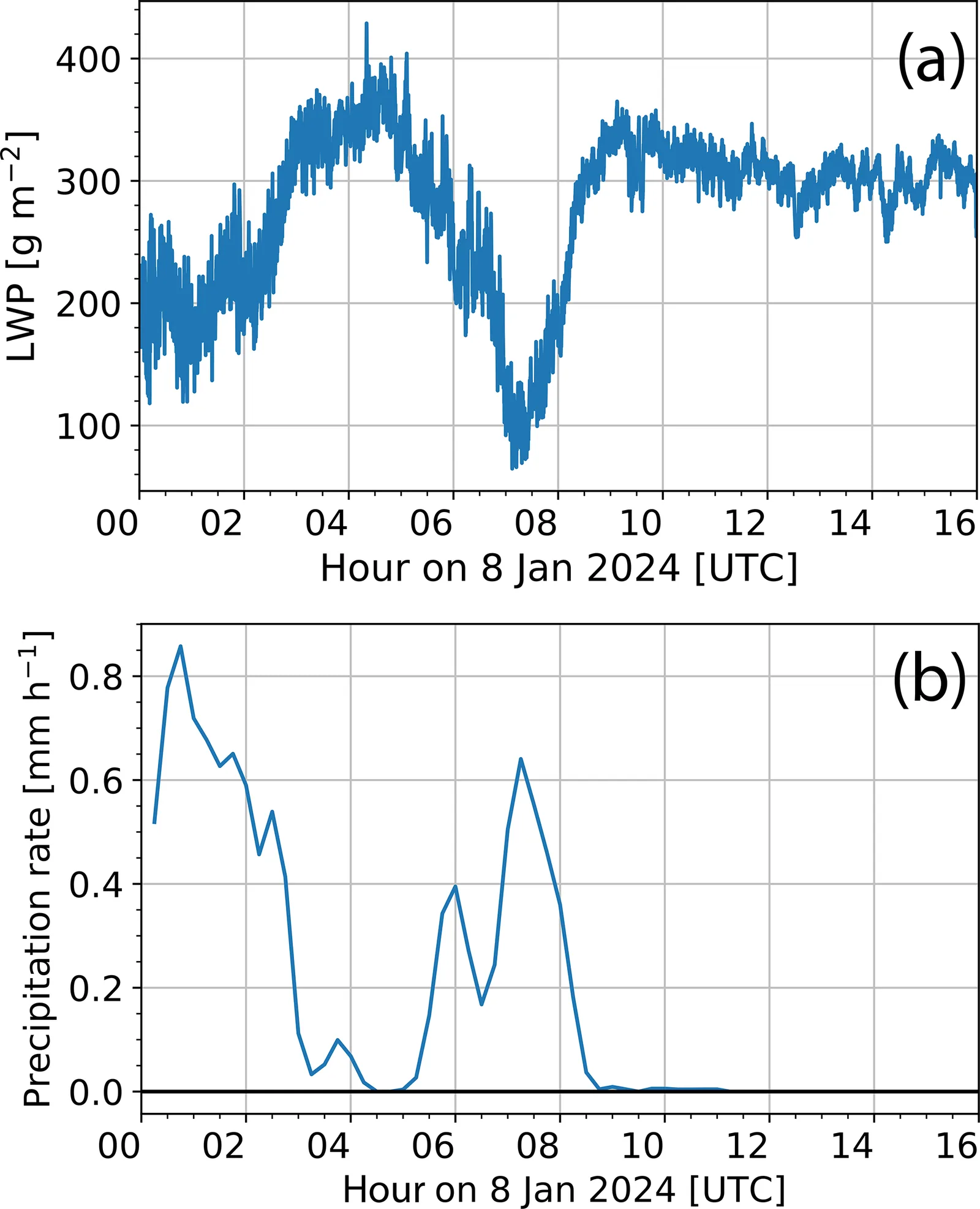
- Liquid water path fell when precipitation rose. From this the authors estimate that 20 %–40 % of precipitation came from the feeder cloud, but this depends strongly on an assumed liquid regeneration rate.
- ICON-D2 slightly underestimated precipitation during seeding and overestimated it without seeding.
Limitations
- This is a single case study, so the model bias and the process picture may not hold generally.
- The 20 %–40 % feeder contribution rests on an assumed regeneration rate of liquid water and is highly uncertain.
- Fall streak tracking is less reliable under wind shear, and radar retrievals could not clearly separate aggregation, riming and liquid water at 3.0–3.8 km.
Glossary
- Seeder-feeder mechanism: Ice crystals from an upper cloud fall into a lower cloud of supercooled droplets and grow, enhancing precipitation.
- Riming: Supercooled droplets freeze onto falling ice crystals, making them heavier and rounder.
- Liquid water path (LWP): The total amount of liquid water in a column of air, per unit area.
- Dual-wavelength ratio (DWR): The difference in radar reflectivity between two radar wavelengths, which gives information on particle size.
Original paper
Impact of seeder-feeder cloud interaction on precipitation formation: a case study based on extensive remote-sensing, in situ and model data
Atmospheric Chemistry and Physics · 2 December 2025
AI-generated summary of the original article; changes were made. Check the original before relying on it.