Model runs show the 2023 North Atlantic marine heatwave could have been far worse
In a climate model, starting conditions like those of the 2023 North Atlantic marine heatwave can evolve into events much longer and hotter than the observed one.
Why it matters
The observed 2023 event is only one possible outcome of its starting conditions. Worse outcomes are physically consistent, so risk planning should not rely on the record alone. The study also suggests that spring ocean and air conditions may give early hints of whether a heatwave fades or grows.
What they did
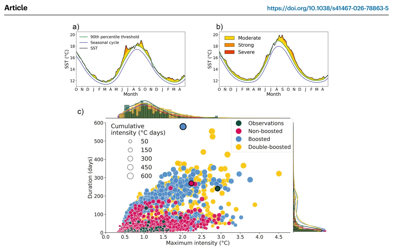
The authors picked a 2023-like marine heatwave from a 30-member run of the GFDL-ESM2M climate model at present-day warming. They reran it many times with tiny random changes to the starting air temperature, a method called ensemble boosting. They did this twice, the second time on the most extreme result. They studied the surface-ocean heat budget of the longest and most intense events. They also checked how often extreme events occur at 1.5 °C, 2 °C, 2.5 °C and 3 °C of global warming.
Key findings
- Boosted events lasted up to 579 days, reached 4.5 °C above climatology, and had cumulative intensities up to 717 °C·days. The observed event had 240 days, 2.9 °C and 224 °C·days.
- Most boosted events were not more extreme than the starting event. Only 1.8% lasted longer than 269 days, and 1.6% exceeded its cumulative intensity.
- The most intense events had a much stronger Euro-Atlantic high pressure in late spring and early summer. This brought less cloud, more sunlight and weaker winds.
- The longest event kept its warmth through heat stored below the surface. Strong winds mixed heat downward, and it later returned toward the surface.
- At higher global warming levels, events as extreme as the boosted ones become more common, especially above 2.5 °C.
Limitations
- The model is coarse and only one model is used, so small-scale ocean processes may be missed and model choices may limit the extremes sampled.
- The results do not set an upper bound on possible extremes. Exceedance probabilities are conditional, so formal return periods cannot be estimated.
- The warming-level analysis samples the broad model distribution, not events tied to the 2023 starting state.
Glossary
- Ensemble boosting: Rerunning a model from just before an event, with tiny random changes, to produce many alternative versions of it.
- Cumulative intensity: The temperature anomaly added up over the whole length of a marine heatwave, in °C·days.
- Global warming level: A 20-year period in which global mean temperature first reaches a set warming above pre-industrial.
- Marine heatwave: A spell of at least five days when sea surface temperature exceeds the seasonal 90th-percentile threshold.
Original paper
The 2023 North Atlantic marine heatwave could have evolved into a far more extreme event
Nature Communications · 19 October 2026
AI-generated summary of the original article; changes were made. Check the original before relying on it.