A deep learning model outlines nighttime urban floods better than six other models tested
The NWseg model, built for low-light images, outlined flooded areas in nighttime street camera images more accurately than the six other segmentation models the authors compared it with.
Why it matters
Most image-based flood mapping has focused on daytime, yet nights are a period of frequent flooding. A model that works in the dark could let city traffic cameras help with flood monitoring and emergency response. The authors note it is still heavy to run and has limits in very dark scenes.
What they did
The authors collected 4000 nighttime urban flood images from the web and hand-labelled the flooded areas. Three annotators worked independently and then resolved differences. They built NWseg, which splits each image into a lighting part and a content part and then fuses them. They compared it with DeepLabv3+, two DeepLabv3+ variants with different backbones, ResNet50-FCN, LRASPP and U-Net, using four standard scores. They also tried all seven models on a strong-lighting scene and a nighttime rain scene.
Key findings
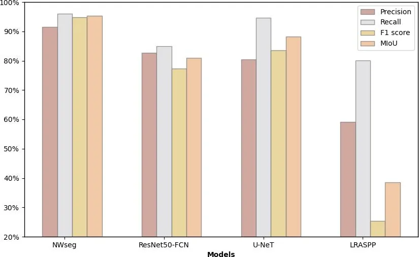
- NWseg scored 95.99 % precision, 94.8 % recall, 95.39 % F1 and 91.46 % MIoU on the test set, the best of all models.
- Swapping the DeepLabv3+ backbone for ResNet101 raised precision by 14.4 % and MIoU by 5.91 % over the baseline, but still left a clear gap to NWseg.
- Against ResNet50-FCN, NWseg was higher on every score. Against U-Net, precision was similar but recall, F1 and MIoU were higher.
- LRASPP did worst, with NWseg’s recall 69.41 % higher.
- In the strong-light and rainy night scenes, NWseg captured flood edges best, while ResNet50-FCN and U-Net had some false detections.
- NWseg ran at 37.8 FPS on an RTX 3080 GPU.
Limitations
- NWseg is complex and has many parameters, which limits use on small edge devices.
- Performance drops sharply in extremely dark scenes or during a power blackout, and the model cannot estimate flood depth or area.
- Images come mainly from typical Chinese cities and surveillance cameras, so it may generalise poorly to other urban layouts and lighting.
Glossary
- Semantic segmentation: Labelling every pixel of an image with a class, here flooded or not flooded.
- MIoU: Mean Intersection over Union: the average overlap between predicted and true regions, relative to their combined area.
- Retinex theory: The idea that an image is the product of a lighting-independent reflectance and an illumination component.
- Backbone: The part of a network that extracts basic image features before the final prediction.
Original paper
Identification of nighttime urban flood inundation extent using deep learning
Natural Hazards and Earth System Sciences · 5 November 2025
AI-generated summary of the original article; changes were made. Check the original before relying on it.