Aircraft saw a 9.6 K gravity wave over Typhoon Hinnamnor, three times ERA5's value
A rare aircraft flight over a supertyphoon measured a gravity wave far stronger than ERA5 shows, suggesting reanalysis and satellites underestimate these waves.
Why it matters
Gravity waves over tropical cyclones can form cirrus clouds and affect water in the lower stratosphere. If reanalysis and satellites understate their strength, estimates of this water budget may be off. The authors argue that more fine-scale observations are needed.
What they did
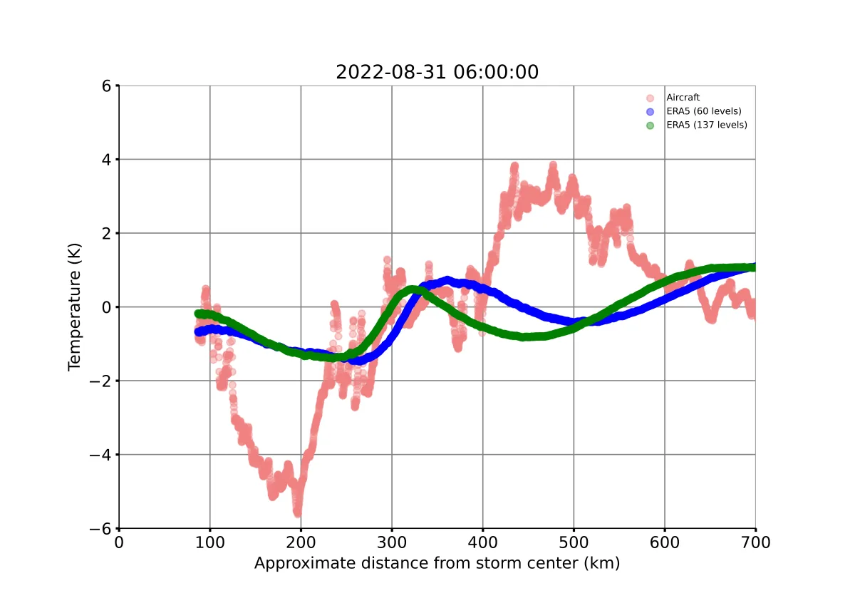
The NASA WB-57 aircraft flew near the top of supertyphoon Hinnamnor on 31 August 2022 during the ACCLIP campaign. The team measured temperature, ozone, water vapor and cirrus, and used the ozone-temperature link to identify a gravity wave. They compared this with ERA5 reanalysis along the flight track. They also compared it with a sample of 114 Western Pacific typhoons of Category 3 and above from 2000–2022. Finally, they compared rapid intensification in observed winds and in ERA5 winds.
Key findings
- The aircraft measured a 9.6 K peak-to-peak temperature wave at about 18 km, while ERA5 gave a maximum of 2.7 K along the same track.
- The measured wave would fall at the 97th percentile of the ERA5 sample. Hinnamnor in ERA5 sat at the 44th percentile.
- Gravity waves are near-ubiquitous in ERA5 typhoons, but their amplitudes look too small.
- In observed winds, about 79 % of typhoons undergo rapid intensification at least once. In ERA5, only 14 % show one episode and none show two.
- A 5-km reanalysis (RRJ-ClimCORE) also gave only about 3 K along the flight track.
Limitations
- This is one overflight of one storm, and the flight only sampled half a wavelength along an arbitrary track.
- The link between ERA5’s missing rapid intensification and its weak waves is inferred, not directly tested.
- The study is a preprint and has not been peer reviewed.
Glossary
- Gravity wave: A wave in the atmosphere where air parcels are pushed up and down and pulled back by buoyancy.
- Reanalysis: A past weather record rebuilt by fitting a fixed forecast model to observations, such as ERA5.
- Rapid intensification: A jump in storm wind speed of at least 30 kts in 24 hours.
- Peak-to-peak amplitude: The difference between the highest and lowest temperature in a wave.
Original paper
In situ observations of gravity waves over tropical cyclone Hinnamnor (2022) suggest that TC gravity wave amplitudes are underestimated in ERA5 reanalysis
EGUsphere · 26 August 2026
This paper is a preprint. It has not been peer reviewed, and its results may change.
AI-generated summary of the original article; changes were made. Check the original before relying on it.