Meteosat-12 Lightning Imager detected 76.3 % of strikes on an instrumented wind turbine
Checked against direct current measurements at one wind turbine, the Meteosat-12 Lightning Imager saw most upward flashes, mainly through cloud-top light from the wider flash rather than the strike point.
Why it matters
Ground-based lightning location systems often miss long, steady currents in upward lightning. This study suggests the satellite imager can add information on such flashes. The authors say this needs larger datasets before any operational use, such as power-system fault attribution.
What they did
The team used 76 lightning currents measured with Rogowski coils on a wind turbine in Croatia, from July 2024 to February 2026. For each one, they pulled Lightning Imager groups within 50 km. They checked two windows: 500 ms before current onset, and the span of the measured current. A flash counted as detected if at least one group appeared in a window. Two flashes were studied in detail using a ground lightning location system.
Key findings
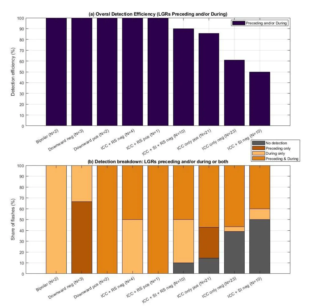
- Overall detection efficiency was 76.3 %, with 61.8 % in the preceding window and 65.8 % during current flow.
- Flashes with pulse-type currents such as return strokes were generally detected more often during current flow. Negative ICC-only and ICC plus superimposed-pulse flashes were missed most.
- Before current onset, positive flashes were detected more often than negative ones: 87.5 % versus 52 %. During current flow, rates were similar: 63 % versus 66 %.
- Night detection was modestly higher than day: 78.4 % versus 74.4 % overall.
- Imager groups appear to show the cloud-top light of the wider lightning process, not the local attachment at the turbine.
Limitations
- All data come from one turbine in a winter-lightning region, with few cases per flash class. The authors treat the polarity and flash-type patterns as features of this dataset, not general rules.
- Day and night groups differ in flash-type mix, which complicates the day/night comparison.
- Light seen before current onset cannot by itself show what triggered the flash. Storm type and cloud optical depth were not analysed.
Glossary
- Initial continuous current (ICC): A long, steady current that flows at the start of an upward flash from a tall structure.
- Lightning Imager group (LGR): A cluster of connected optical lightning events seen within one 1 ms frame, with a time, place and radiance.
- Return stroke (RS): A sharp, bright current pulse that follows a leader connecting to the ground or a structure.
- Lightning location system (LLS): A ground network that finds lightning from its radio signals.
Original paper
Systematic Evaluation of the Meteosat-12 Lightning Imager Using Direct Lightning Current Measurements from an Instrumented Wind Turbine
EGUsphere · 6 October 2026
This paper is a preprint. It has not been peer reviewed, and its results may change.
AI-generated summary of the original article; changes were made. Check the original before relying on it.