Stalled low-pressure systems and tropical waves keep Great Barrier Reef doldrums going
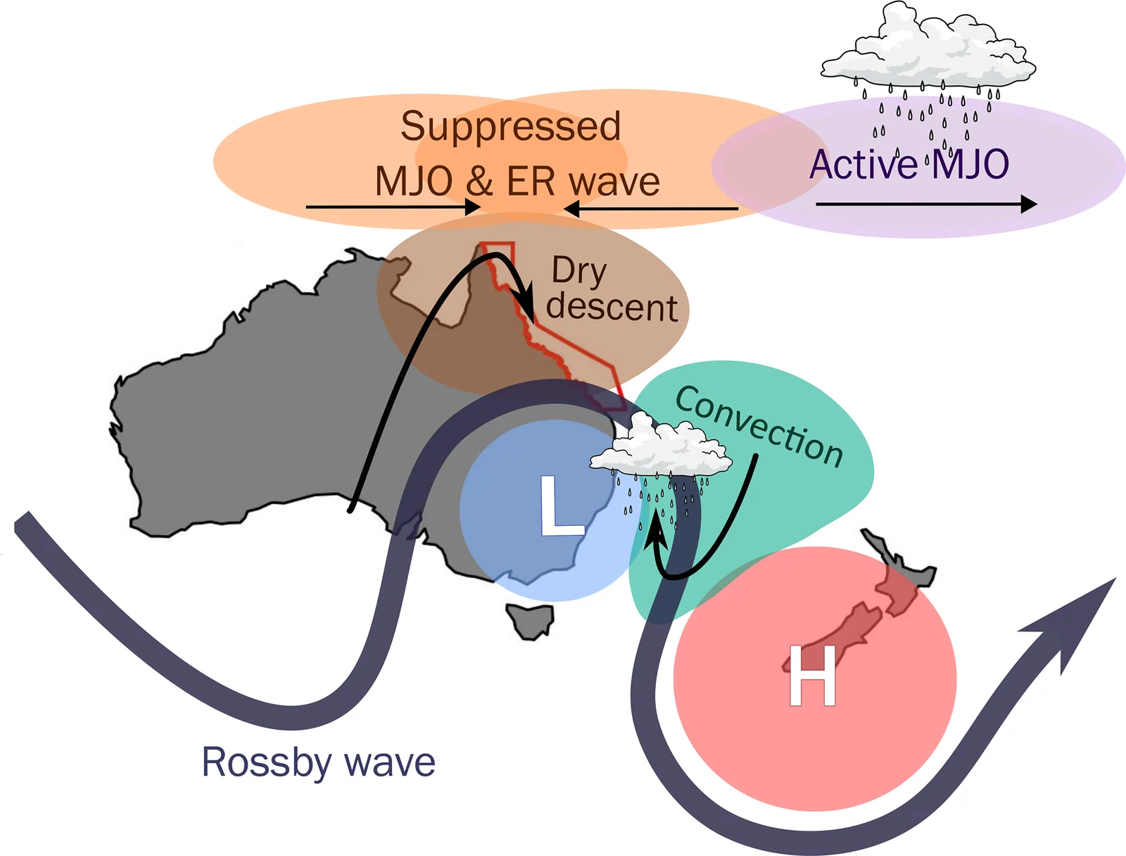
Doldrums over the Great Barrier Reef last longer when a cyclonic anomaly stalls over south-east Australia and tropical waves line up to keep westerly winds opposing the trade winds.
Why it matters
Doldrums let the sea surface heat up, which can lead to marine heatwaves and coral bleaching. Knowing what makes them persist points to the weather patterns forecasters could watch. The same setup is linked to land heatwaves in the region, so it may help forecast both marine and land heat.
What they did
The authors used a K-means cluster analysis of December–April weather at Davies Reef (1996–2024) to find doldrums days. They split events into short (2 days or fewer, 155 samples) and long (5 days or more, 57 samples). Using ERA5 reanalysis, they built composites centred on the first day of each event. They looked at mid-latitude Rossby waves, wave breaking, blocking, the Madden–Julian Oscillation and Equatorial Rossby waves. They also ran back trajectories to trace the dry descending air.
Key findings
- In short events, the cyclonic anomaly moves quickly east and the trade winds return. In long events it stalls, so anomalous westerlies stay over the reef.
- Long events show repeated cyclonic Rossby wave breaking over Australia and more blocking near New Zealand.
- In long events, suppressed phases of the MJO and Equatorial Rossby wave more often sit over the reef, and the active MJO to the east adds to the westerlies.
- Dry descending air above the doldrums mostly comes from the mid-latitudes. It sweeps across southern Australia around the low before reaching the reef.
- The patterns resemble those of south-east Queensland heatwaves, which suggests a shared weather setup for marine and land heat.
Limitations
- Each day is classed as doldrums from the 00:00 UTC profile at one site only. Events can be split by one non-doldrums day, so durations may be underestimated.
- The clustering ignores day-night changes and may not represent night-time doldrums.
- The study covers weather scales only. It does not examine year-to-year modes such as El Niño, the monsoon or future climate change.
Glossary
- Doldrums: Calm, weak-wind conditions, here over the Great Barrier Reef, when the usual trade winds break down.
- Rossby wave breaking: Rapid overturning of the upper-level jet stream waves, which can form cut-off lows and blocking highs.
- Dry intrusion: A stream of dry air that descends from higher up, often linked to wave breaking.
- Warm conveyor belt: A stream of warm, moist air that rises and moves poleward ahead of a cyclone.
Original paper
The development and persistence of doldrums over the Great Barrier Reef
Weather and Climate Dynamics · 13 October 2026
AI-generated summary of the original article; changes were made. Check the original before relying on it.