AI and machine learning
New weather and climate research on ai and machine learning, one page per paper.
All summaries
-
 AI and machine learning
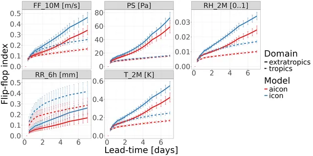
A 13 km machine learning weather model matches ICON on near-surface forecasts
AICON, a graph neural network trained on high-resolution ICON data without multi-step rollout, is now operational at DWD and competes with ICON near the surface, but it smooths fine scales and underestimates cyclone intensity.
-
 AI and machine learning
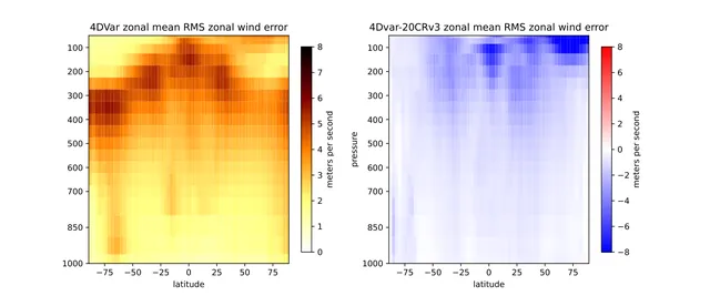
Long-window 4D-Var with NeuralGCM beats 20CRv3 using only surface pressure
A differentiable weather model lets a simple long-window 4D-Var, with no background-error term, fit surface-pressure observations and give analyses closer to ERA5 than 20CRv3 over three months.
-
 AI and machine learning
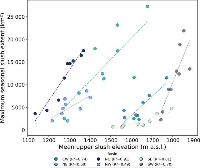
Slush covers far more of Greenland's ice sheet than lakes, channels and crevasses combined
A nine-year satellite map shows slush is the largest mapped surface meltwater feature on the Greenland Ice Sheet, growing and reaching higher in high-melt years.
-
 AI and machine learning
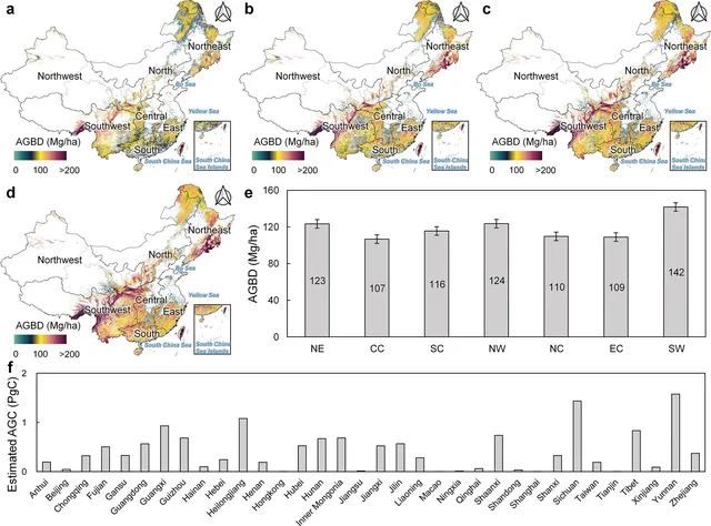
China's forest biomass density rose from 95.74 to 122.69 Mg per hectare between 1985 and 2023
A 30 m annual map of China's forest biomass from 1985 to 2023 shows aboveground carbon stock rising from 5.50 to 13.97 PgC, mostly through growth of existing forest.
-
 AI and machine learning
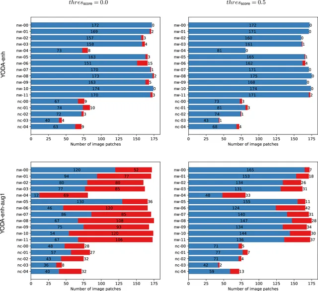
Open Sentinel-1 dataset labels oil slicks and look-alikes in the Eastern Mediterranean
The authors released a labeled set of radar image patches with 3225 oil objects and many look-alike scenes, so oil spill detectors can be tested on a common benchmark.
-
 AI and machine learning
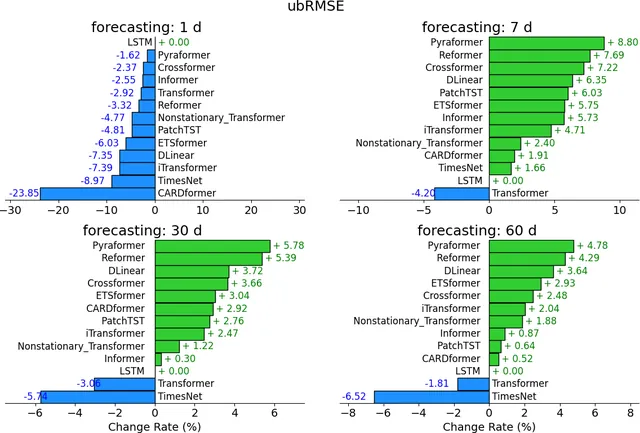
LSTM beats Transformers on standard hydrology tasks, but attention models win on harder ones
In a benchmark of 11 Transformer-type models against an LSTM, the LSTM was best at regression and short forecasts, while attention-based models did better at long-horizon autoregression and zero-shot forecasting.
-
 AI and machine learning
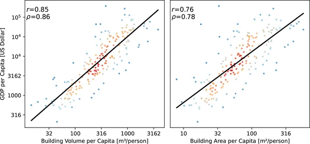
Open global dataset maps 2.75 billion buildings with heights from satellite images
Using only PlanetScope satellite images plus existing footprint data, the authors built the first complete global set of building outlines, 3 m height maps and simple 3D models, with height errors of 1.5 to 8.9 m by continent.
-
 AI and machine learning
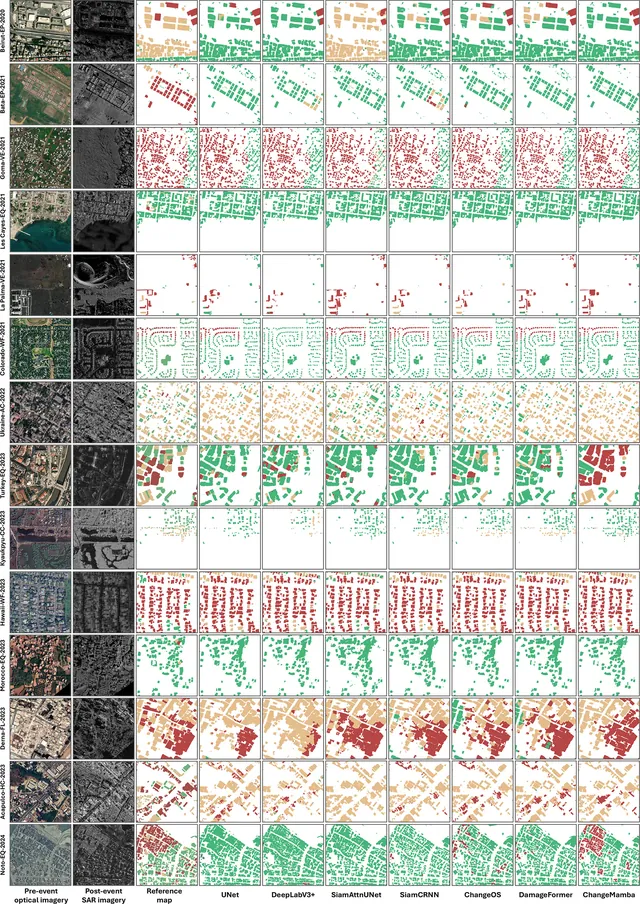
New open dataset pairs pre-event optical and post-event radar images to map building damage
Bright is the first open, global dataset combining pre-disaster optical and post-disaster radar images of buildings, and models trained on it work well within known events but struggle on new ones.
-
 AI and machine learning
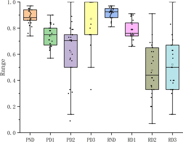
Rainfall-based drought index is the top predictor of hydrological drought in the Huaihe Basin
An XGBoost model predicted next-month hydrological drought category correctly 79.9 % of the time in the Huaihe River Basin, and the precipitation drought index (SPI) mattered most, though it was weak on severe drought.
-
 AI and machine learning
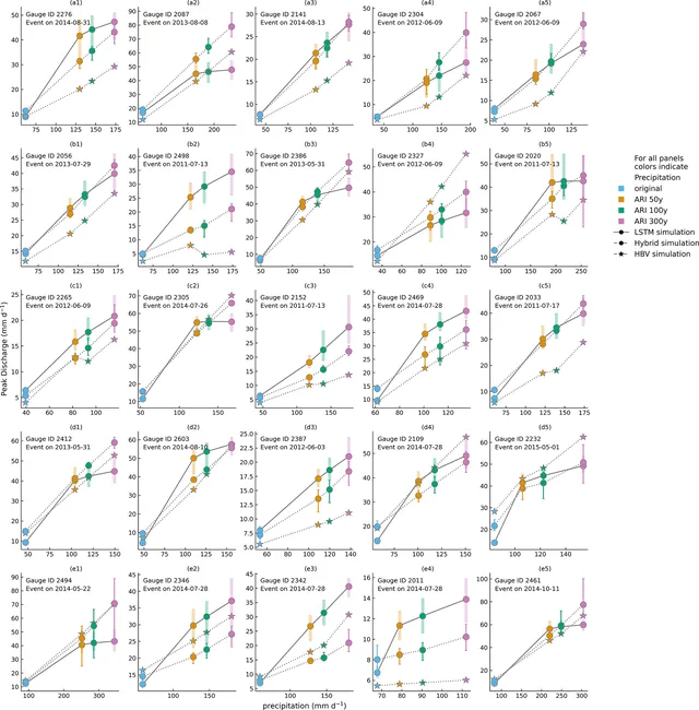
Stand-alone LSTMs cannot predict river flows above a limit set below their training peak
When fed extreme design rainfall, a stand-alone LSTM runoff model hits a ceiling well below flows it saw in training, and its runoff share falls as rain rises, while a hybrid model scales more sensibly.
-
 AI and machine learning
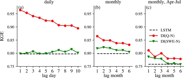
Feeding past streamflow into an LSTM sharply improves Western U.S. streamflow estimates
Giving an LSTM recent streamflow observations raises its accuracy most at the daily scale, while snow observations help only at the monthly scale, mainly in snow-dominated basins.