Models and methods
New weather and climate research on models and methods, one page per paper.
All summaries
-
 Models and methods
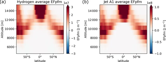
Hydrogen aircraft contrail cirrus forcing is modelled as 66 % lower than for jet fuel
In a model, hydrogen-powered aircraft make contrail cirrus with much less warming than jet fuel aircraft in most cases, but lubrication oil droplets could erase the benefit.
-
 Models and methods
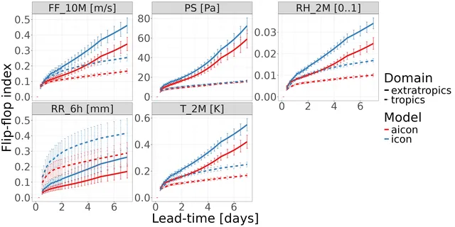
A 13 km machine learning weather model matches ICON on near-surface forecasts
AICON, a graph neural network trained on high-resolution ICON data without multi-step rollout, is now operational at DWD and competes with ICON near the surface, but it smooths fine scales and underestimates cyclone intensity.
-
 Models and methods
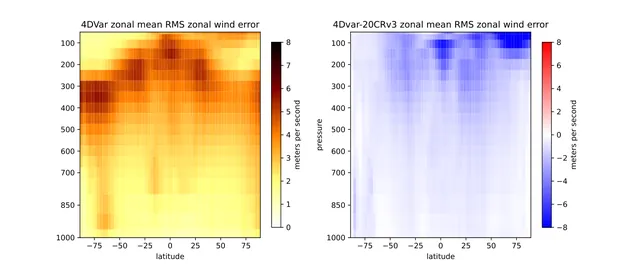
Long-window 4D-Var with NeuralGCM beats 20CRv3 using only surface pressure
A differentiable weather model lets a simple long-window 4D-Var, with no background-error term, fit surface-pressure observations and give analyses closer to ERA5 than 20CRv3 over three months.
-
 Models and methods
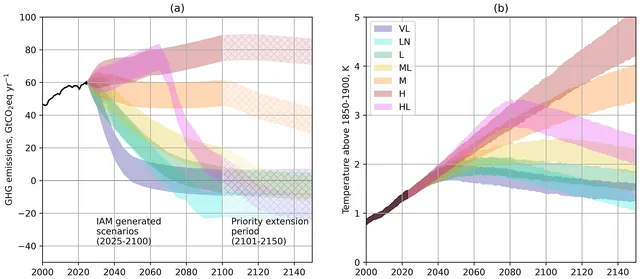
CMIP7 proposes seven emission scenarios, run mostly in emission-driven mode
ScenarioMIP for CMIP7 sets out seven emission scenarios, from High to Very Low, to be run mostly with CO2 emissions driving the models, with some extended to 2500.
-
 Models and methods
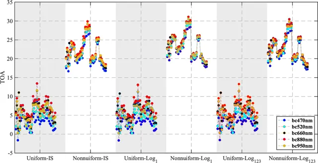
Realistic particle size and mixing shift black carbon radiative forcing in a coal region
In an industrial coal region of Shanxi, using the observed three-peak particle size and internal mixing, instead of simple standard assumptions, changes estimated absorption and radiative forcing by amounts comparable to local greenhouse gas forcing.
-
 Models and methods
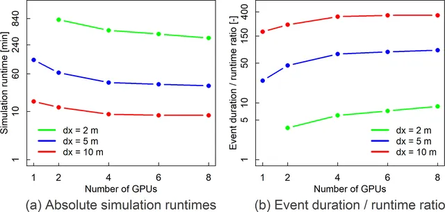
Multi-GPU model simulates a Berlin-wide flood at 5 m resolution in 34 minutes
With eight GPUs, the RIM2D flood model can simulate a 48-hour rainstorm over all of Berlin fast enough for early warning, at 10 m, 5 m and even 2 m resolution.
-
 Models and methods
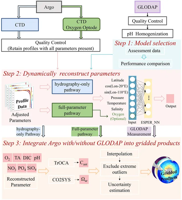
Argo floats and machine learning yield gridded Southern Ocean carbon maps to 5600 m
The authors used a neural network to turn Argo float temperature, salinity and sometimes oxygen into 1°×1° maps of Southern Ocean carbon chemistry, including anthropogenic carbon, with uncertainties.
-
 Models and methods
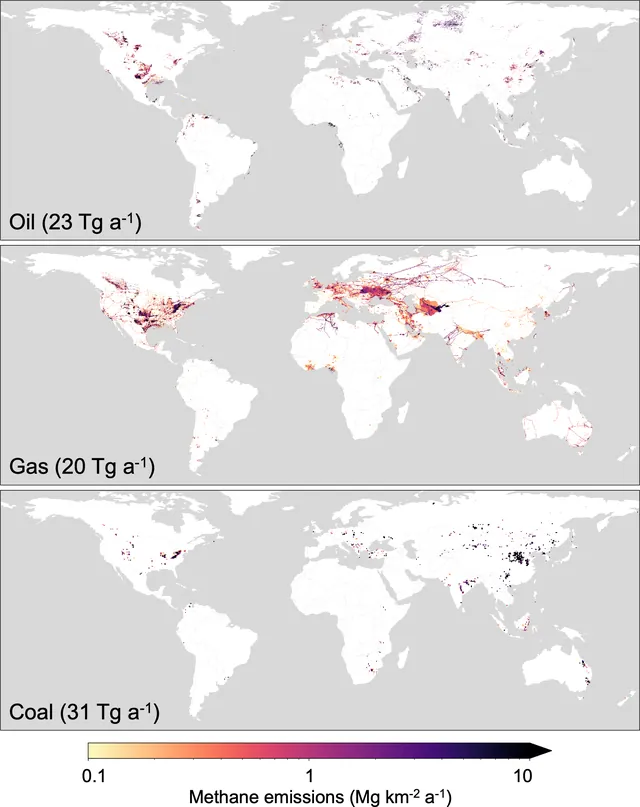
New global methane inventory for oil, gas and coal totals 74 Tg a−1 in 2020
GFEI v3 maps nationally reported 2020 fossil fuel methane emissions onto a 0.1° grid using new infrastructure and coal mine data, and it stays below other inventories and satellite-based estimates.
-
 Models and methods
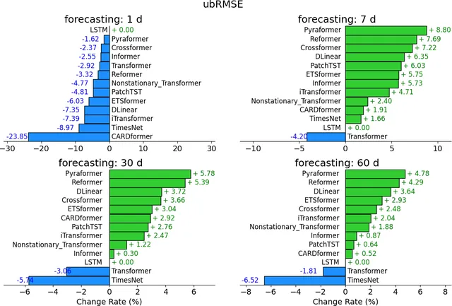
LSTM beats Transformers on standard hydrology tasks, but attention models win on harder ones
In a benchmark of 11 Transformer-type models against an LSTM, the LSTM was best at regression and short forecasts, while attention-based models did better at long-horizon autoregression and zero-shot forecasting.
-
 Models and methods
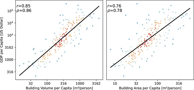
Open global dataset maps 2.75 billion buildings with heights from satellite images
Using only PlanetScope satellite images plus existing footprint data, the authors built the first complete global set of building outlines, 3 m height maps and simple 3D models, with height errors of 1.5 to 8.9 m by continent.
-
 Models and methods
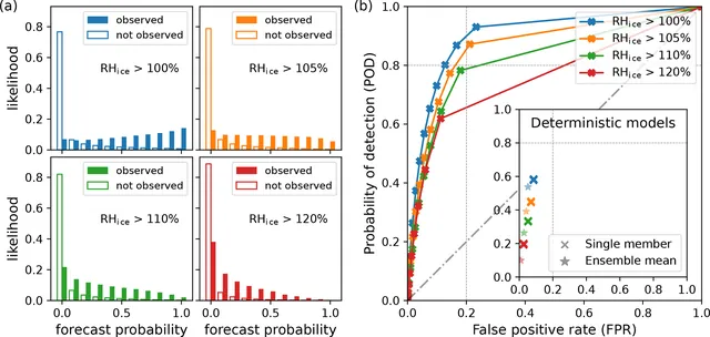
Ten-member ICON ensemble with two-moment ice scheme detects more ice-supersaturated air
Adding a two-moment ice scheme and a ten-member ensemble to the ICON model raises the share of ice-supersaturated regions detected from 0.4 to 0.6 for one run, and to 0.8 for a three-member vote.
-
 Models and methods
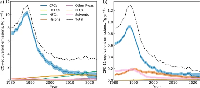
AGAGE data show 2023 emissions and levels of 42 trace gases, with limits
Using AGAGE station measurements and a simple 12-box atmosphere model, the authors publish yearly global emissions and abundances for 42 trace gases through 2023, and explain how they are derived and where they fall short.
-
 Models and methods
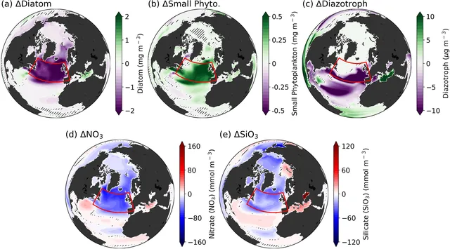
Subpolar North Atlantic plankton stay smaller even after CO2 returns to its starting level
In a climate model, removing CO2 back to its starting level does not bring back large diatoms in the Subpolar North Atlantic, because weaker ocean circulation keeps surface nutrients low, and this cuts carbon export.
-
 Models and methods
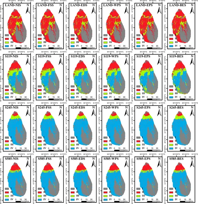
Agricultural expansion aggravates water shortage more than climate change
Agricultural land expansion, not climate change, is the primary driver of intensifying water crises in arid regions.
-
 Models and methods
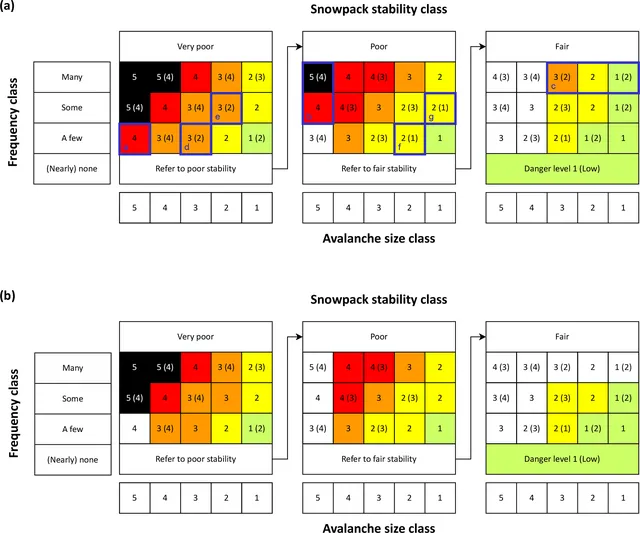
New EAWS Matrix standardizes avalanche danger assessment across Europe
The EAWS Matrix is a decision-support tool developed by European avalanche forecasters that assigns danger levels by linking snowpack stability, how frequently it occurs, and expected avalanche size.
-
 Models and methods
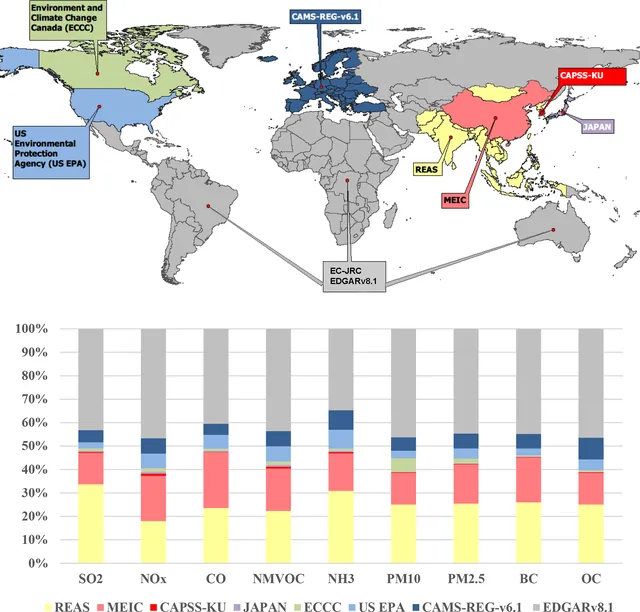
A global air pollutant emission mosaic now covers 2000–2020 at monthly resolution
HTAP_v3.2 blends official regional emission inventories with the EDGAR global inventory into one monthly, gridded dataset for nine air pollutants over 2000–2020.
-
 Models and methods
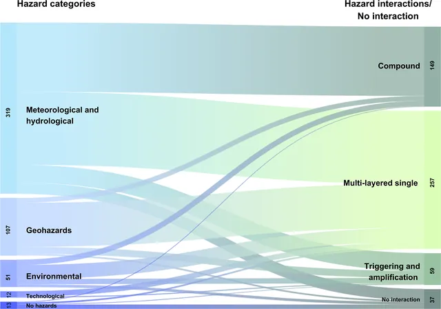
Review of 192 papers finds few indicators built for multi-hazard or multi-risk use
Many studies labelled multi-hazard simply layer separate single-hazard results, and few develop indicators that capture how hazards interact or how risks combine.
-
 Models and methods
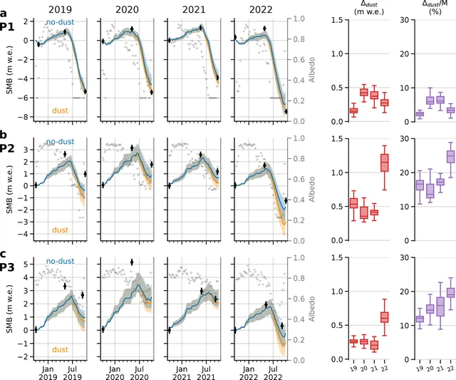
Saharan dust cut Argentière Glacier's 2022 mass balance by 0.63 m w.e., double earlier years
In a snow model of Argentière Glacier, mineral dust lowered annual surface mass balance by 0.31 to 0.45 m w.e. in 2019–2021 and by 0.63 m w.e. in 2022, most strongly just above the previous summer's snowline.
-
 Models and methods
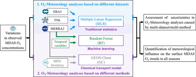
Weather pushed up China's ozone trends in all seasons, but methods disagree most
Across three weather datasets and three methods, meteorology almost always raised China's surface ozone from 2013 to 2022, but the choice of method changes the size of that effect more than the choice of dataset.
-
 Models and methods
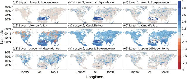
Soil moisture falls as precipitation rises in some dry and cold Northern Hemisphere regions
In parts of the Northern Hemisphere, mostly deserts, montane shrublands and tundra, soil moisture can be negatively tied to precipitation, and temperature and vegetation productivity help explain it.
-
 Models and methods
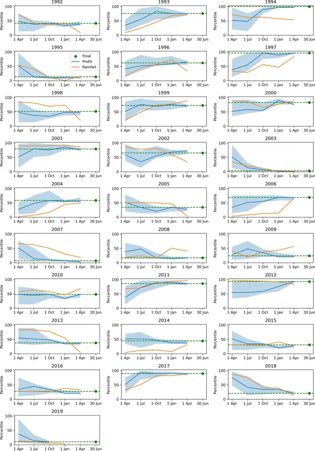
Integrated agricultural models forecast drought impacts sooner than rainfall
An integrated system forecasting farm profits and crop yields provides reliable drought warnings months ahead of rainfall-based indicators.
-
 Models and methods
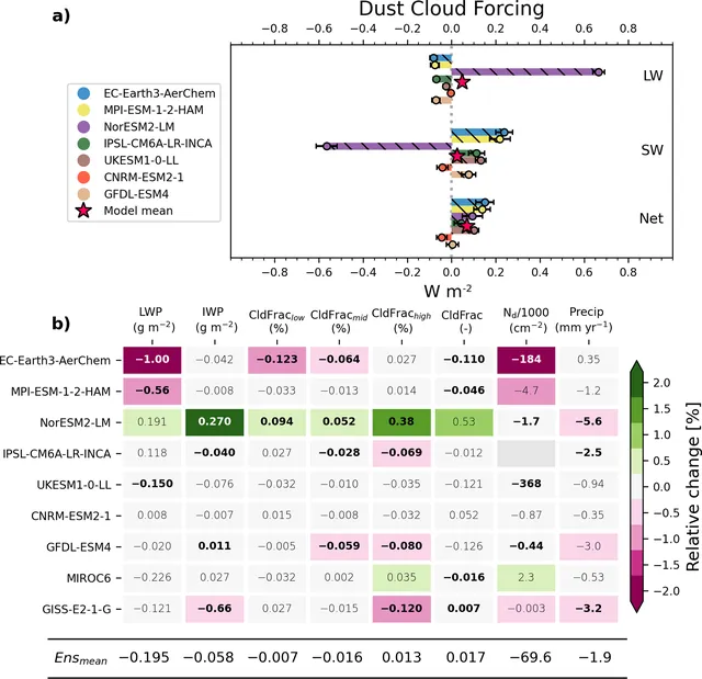
Nine climate models disagree widely on dust forcing, but agree dust cuts precipitation
When nine CMIP6 models double dust emissions, they differ a lot in how much energy dust adds or removes, yet eight of nine show less precipitation.
-
 Models and methods
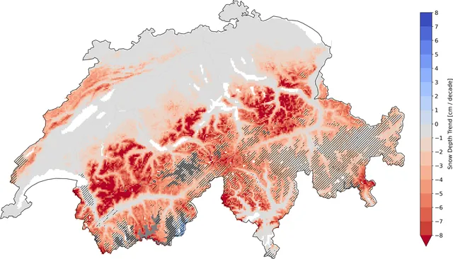
New 60-year Swiss snow maps track stations well, except at low elevations
A quantile-mapped snow model gives 1 km daily Swiss snow data since 1962 that works well above 1000 m and for yearly or regional use, but is weaker at low elevations, single grid points and short time spans.
-
 Models and methods
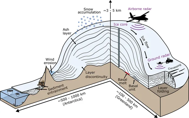
Radar-imaged ice layers could be built into a continent-wide age–depth model of Antarctica
Six decades of radar surveys have recorded dated layers inside Antarctic ice, but only a small part has been traced, and a community effort is needed to turn it into a continent-wide age model.
-
 Models and methods
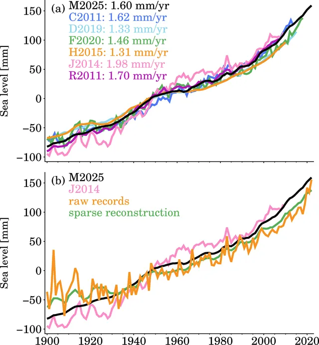
Sea level rebuilt at 945 tide gauges since 1900 shows a rise of 1.75 mm per year
The authors filled the gaps in 945 tide gauge records from 1900 to 2022 with a physics-based method, and the result matches other global sea level curves while following the raw records where they exist.
-
 Models and methods
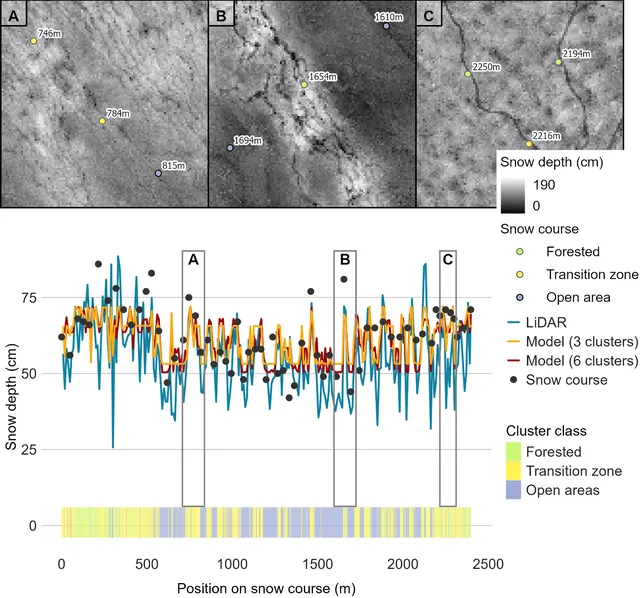
Drone LiDAR and clustering give daily snow depth and SWE maps in Finnish boreal sites
One winter of drone LiDAR surveys, grouped into three snow-pattern clusters and paired with daily sensor data, gave 1 m snow depth and SWE maps with SWE errors of 31–36 mm in two Finnish Lapland sites.
-
 Models and methods
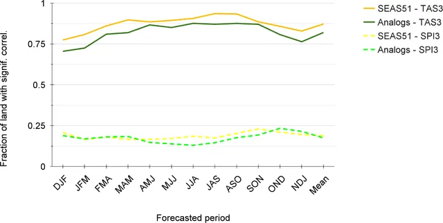
Analog method gives skillful temperature and rainfall-index forecasts from seasons to years
Picking climate-model years whose ocean temperatures match today's observed pattern gives seasonal to multi-year forecasts that are close to operational systems at far lower computing cost.
-
 Models and methods
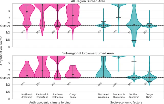
Fire emissions ran 9 % above average in 2024–2025 despite less burned area
The 2024–2025 fire season released more carbon than average even though less land burned, and the report's models find climate change made four extreme regional fire events more likely.
-
 Models and methods
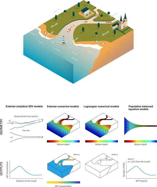
Review compares four ways to model microplastics in estuaries and sets out good practice
Most estuary microplastic models use particle tracking, but all approaches are limited by scarce field data for inputs and validation, so models should be kept as simple as the question allows and tested with sensitivity runs.